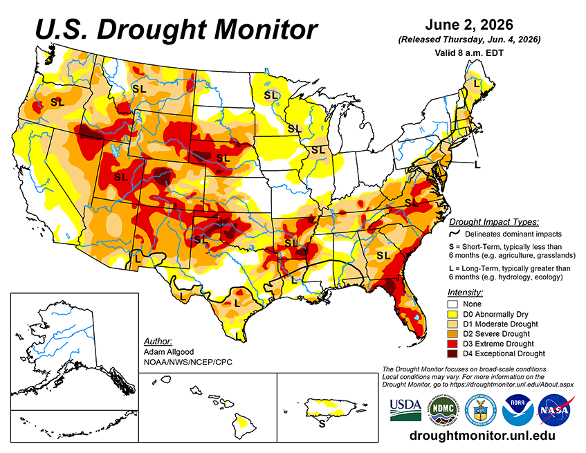
At the start of the next 7 days, drier conditions are favored across much of the East, with daily temperatures quickly warming to above-normal. A storm system now over the Plains will progress slowly eastward, bringing a potential for much needed rainfall across the upper Midwest and Great Lakes region. Current QPF forecasts from the Weather Prediction Center show amounts potentially exceeding 1.5 inches across much of Iowa and far southwestern Wisconsin, but lighter amounts elsewhere will likely be insufficient to overcome the high demands coming from much above-normal temperatures and summer agriculture, especially across Illinois, Indiana, and northern Minnesota. A gradual return to a summer convective regime is favored across the Southeast during the week, but accumulations are forecast to be less than what fell over the past few weeks, especially across northern Florida and east of the Appalachians. Seabreeze-driven convection is favored to remain active across South Florida. Mostly dry conditions are favored across the West, with a storm system bringing some precipitation to the Pacific Northwest. Meager precipitation is forecast for the Northeast region, raising concerns for a return of short term drought impacts.
During Week-2, weak troughing over Alaska is favored to maintain below-average temperatures and above-average precipitation for another week. Downstream, positive height anomalies are forecast for most of the contiguous United States, leading to coast-to-coast enhanced chances for above-normal temperatures. The highest probabilities for above-normal temperatures extend across both the West and the Northeast. Enhanced low-level southerly flow in this pattern favors a wide open Gulf, with moist air penetrating far to the north across the central US. Any interactions with shortwave troughs or other synoptic features could trigger periods of organized convection. Therefore, a broad signal slightly favoring above-normal precipitation extends from the Gulf Coast through much of the CONUS east of the Rockies. Near normal precipitation is the most likely outcome across the Northeast with weak troughing just offshore, and a slight tilt towards below-normal precipitation is forecast for the Pacific Northwest. Across Hawaii, both above-normal temperatures and precipitation are favored, based on a consensus of dynamical model guidance.