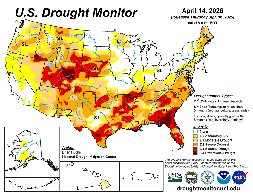
Over the next 5–7 days, precipitation is expected to be most prominent across the southern Plains, Midwest, and Northeast. The heaviest precipitation is likely from eastern Kansas into Missouri and northward into eastern Iowa, northern Illinois, and the Great Lakes.
Additional precipitation is expected from the Pacific Northwest into the northern Rockies and High Plains. Dryness is likely to persist across much of the Southwest and Southeast.
Temperatures are expected to be above normal from the northern Rockies into the High Plains, with the greatest departures in western Nebraska, eastern Colorado, and central Montana (10–13 degrees above normal). Cooler-than-normal temperatures are anticipated across much of central Texas (5–9 degrees below normal), while warmer-than-normal conditions are expected across the Mid-Atlantic (5–7 degrees above normal).
The 6-10 day outlooks show that the locations with the best chances of experiencing below- normal temperatures are in the Southwest, especially those locations in Arizona and southern Nevada and California as well as in New England with the best chances in both Arizona and Maine. There is a high likelihood of above-normal temperatures over much of the Midwest, Plains, and into the South and Southeast with the best chances over Kansas, Missouri, Arkansas, Oklahoma into southern Nebraska and Iowa.
Precipitation chances are expected to be near-normal over southern Florida and southern areas of New Mexico and Arizona. Near-normal precipitation is also expected over the Pacific Northwest, upper Midwest and into the Northern Plains. In the Northeast, there will be a mix of near-normal to below-normal precipitation chances. Most of the rest of the country has above-normal chances of recording above-normal precipitation with the greatest chances over an area from northern Louisiana to Indiana.