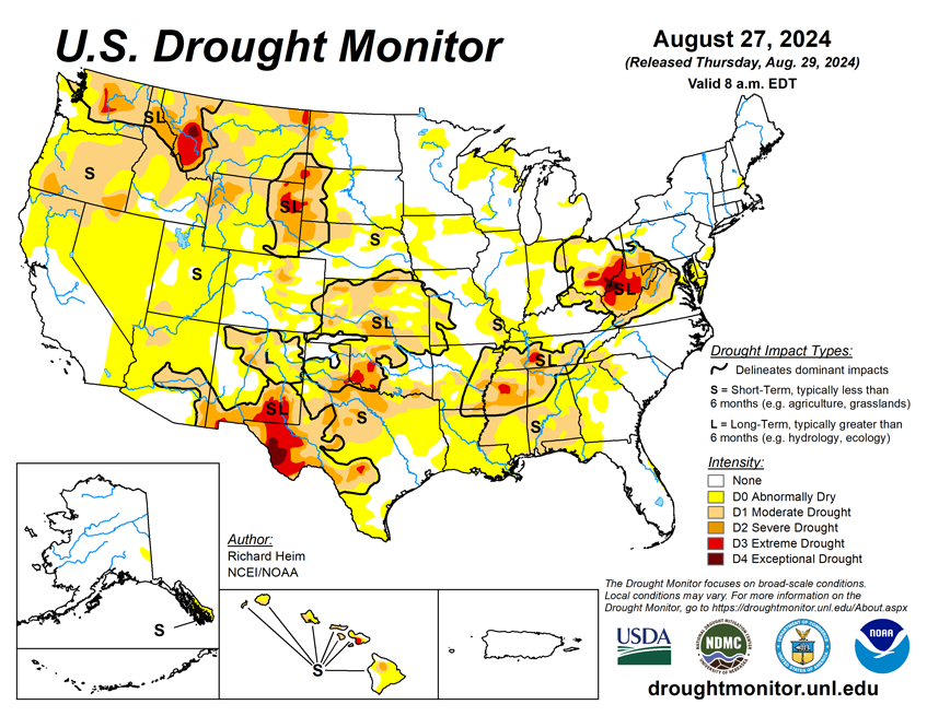
National Current Conditions: August 21, 2024 - August 27, 2024
This week brought expansion of dryness and drought from the Southern Plains to the Southeast. New Extreme Drought (D3) was introduced in Montana, Wyoming, South Dakota, Oklahoma, Texas, Tennessee, Mississippi, Ohio, and West Virginia. And Ohio and West Virginia saw Exceptional Drought (D4) develop—the first time either state has had D4 since the U.S. Drought Monitor began in 2000.
As of August 27, 2024, 23.37% of the U.S. and Puerto Rico and 27.70% of the lower 48 states are in drought, according to the U.S. Drought Monitor.
This Week's Drought Summary…
A strong ridge of high pressure maintained its grip across the central part of the contiguous U.S. (CONUS) during this U.S. Drought Monitor (USDM) week (August 21-27). It was responsible for warmer-than-normal temperatures that stretched across the Plains and into the Upper Midwest. Upper-level troughs of low pressure dominated the West and East coasts, keeping weekly temperatures cooler than normal on both ends of the country. Pacific weather systems spread above-normal precipitation over northern California to the Pacific Northwest as they moved through the western trough, then triggered bands of thunderstorms over the Rockies and central to northern Plains as they bumped up against the ridge. In between the West Coast and Rockies rain areas, the West was dry from southern California to northern Montana. Rain developed along a stationary front that was draped across Florida.
But for most of the CONUS east of the Rockies, the week was drier than normal with little to no rain falling from western Texas to the Mid-Atlantic Coast. The ridge migrated eastward as the week ended, so warmer-than-normal temperatures spread into the Midwest and Southeast. Abnormal dryness and drought expanded and intensified across the southern Plains and Tennessee and Lower Mississippi Valleys in a rapidly developing flash drought situation, as well as parts of the Southeast, Mid-Atlantic, Midwest, northern Plains, and Far West. Exceptional drought (D4) developed in parts of Ohio and West Virginia for the first time in the 25-year USDM history. Hurricane Hone’s rains brought improvement to most of the main Hawaiian Islands.

Looking Ahead...
In the two days since the Tuesday valid time of this USDM, scattered showers and thunderstorms brought areas of rain to a few parts of the Southwest, northern Rockies, northern and southern Plains, Midwest, and Florida, but the rest of the CONUS was mostly dry. For August 29-September 3, an upper-level ridge will build over the West, bringing warmer- and drier-than-normal weather, while a weather system moves across the eastern CONUS and a weather disturbance lingers over the western Gulf of Mexico Coast. An inch or more of rain, with locally over 2 inches, is forecast for the southern Plains to Lower Mississippi Valley, Upper Mississippi Valley, and Carolinas to New York. Four or more inches could fall over parts of the southern Plains, New Mexico, and western Gulf Coast. The rain will help to improve drought conditions in the Deep South and central Appalachians, but won’t be enough to end the drought. The Rockies to West Coast, and western High Plains, are forecast to receive no precipitation during this period.
For much of the next 2 weeks, a ridge will remain anchored over the West with a trough along the East Coast, while a couple weather systems try to move through this upper-level blockade. The Climate Prediction Center’s (CPC) 6-10 Day Outlook (valid September 3-7) and 8-14 Day Outlook (valid September 5-11) favor warmer-than-normal temperatures across the West, central and northern Plains, along the Gulf of Mexico Coast, and over the eastern half of Alaska, with near to cooler-than-normal temperatures expected over parts of the southern Plains and from the Ohio Valley to East Coast. Odds favor below-normal precipitation across most of the West, the northern tier states, the Midwest, the northern and central Plains, and Hawaii. Odds favor above-normal precipitation across the Gulf of Mexico Coast to the Carolinas, and over eastern Alaska.


