Weekly Drought Monitor for the Week ending 3/31/26

Drought in the Lower 48 States increased 6.6% since last week and 17.0% since last month.

This Week's Drought Summary…

This U.S. Drought Monitor (USDM) week saw extensive degradations across areas of the West, Plains, South, and Southeast. Out West, widespread degradations were centered across the Intermountain West, including Colorado, Utah, Idaho, and Wyoming, and to a lesser extent across portions of Arizona, New Mexico, Nevada, and Montana. Continued degradations are expected in the coming weeks and months due to anomalous heat and record-low snowpack levels. In the Plains, drought expanded and intensified from Oklahoma to South Dakota. In the South and Southeast, dry conditions persisted this week, adding to significant longer-term (9- to 12+ month) precipitation deficits (ranging from 8 to 20+ inches), with the most severe drought conditions centered over portions of Texas, Arkansas, Georgia, and Florida. In the Northeast and Midwest, light-to-moderate rainfall (1 to 3 inches) during the past week led to targeted improvements in Illinois, Indiana, Ohio, Pennsylvania, and New York.
At the end of March, mountain snowpack conditions remain well below normal for the time of year, with record to near-record low levels observed across all western states. Additionally, many Natural Resources Conservation Service (NRCS) SNOw TELemetry (SNOTEL) network monitoring stations are reporting very shallow snow depths or no snow on the ground. Region-level (2-digit HUC) snow water equivalent (SWE) values (percent of median) are as follows: Pacific Northwest 55%, Missouri 56%, Upper Colorado 24%, Great Basin 18%, Lower Colorado 14%, Rio Grande 8%, and Arkansas-White-Red 8%. In California, statewide snowpack is 18% of normal (April 1), with the Southern Sierra at 32%, Central Sierra at 21%, and Northern Sierra at 6%. Despite poor snowpack conditions, California’s reservoirs remain at or above historical averages for the date (March 31), with Lake Shasta and Lake Oroville at 113% and 123% of average, respectively. In the Southwest, the U.S. Bureau of Reclamation (March 29) reports critically low levels at Lake Powell (24% full; 41% of average for the date) and Lake Mead (33% full; 52% of average for the date), with the total Colorado River system at 36% of capacity (compared to 41% at the same time last year).


Looking Ahead...

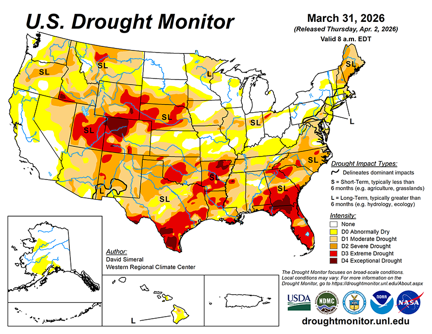
The NWS 7-Day Quantitative Precipitation Forecast (QPF, liquid equivalent) calls for precipitation accumulations generally ranging from 2 to 4 inches across eastern portions of the Southern Plains, Midwest, and Northeast, with the heaviest totals along a corridor from eastern Texas through the Lower Mississippi Valley into portions of the Upper Mississippi Valley. In the Southeast and Mid-Atlantic, light-to-moderate liquid precipitation accumulations ranging from 0.5 to 2 inches are expected. Across the High Plains, light-to-moderate liquid precipitation accumulations ranging from 0.5 to 2 inches are expected, with the greatest totals across portions of the Dakotas. In the West, light-to-moderate liquid precipitation accumulations are expected across areas of the region, with the highest totals across portions of the Pacific Northwest, northern California, and southern Oregon. In the higher elevations, snow is expected across the Sierra Nevada, southern Cascades, northern Great Basin, and portions of the central and northern Rockies. Dry conditions are expected to prevail across much of the Southwest, including areas of southern California, southern Nevada, Arizona, and New Mexico.
The 6–10-day temperature outlook (valid April 7–11, 2026) calls for above-normal temperatures across much of the western U.S., Southern Plains, and areas of the South, with the highest probabilities centered over the California, Nevada, Utah, and Arizona. Below-normal temperatures are favored across the Northern Plains as well as the New England. Near-normal temperatures are expected across much of the eastern U.S., including the Mid-Atlantic and Southeast, as well as portions of Texas. In terms of precipitation, the 6–10-day outlook calls for above-normal precipitation across areas of the eastern half of the western U.S., Plains states, South, much of the Midwest, and Florida. Below-normal precipitation is favored across portions of the Mid-Atlantic and southern extent of New England. Near-normal precipitation is expected across areas outside of these regions, including portions of the western U.S. and Southeast.