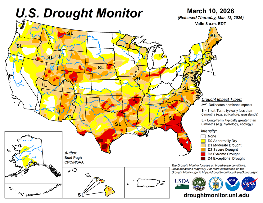
In the wake of a cold front, sharply colder temperatures are forecast to overspread the eastern U.S. on March 12. A second and even stronger cold front is expected to progress east from the Great Plains to the East Coast by March 16. Following this strong March cold front, subfreezing temperatures are forecast to extend as far south as Oklahoma and the Texas Panhandle. According to the Weather Prediction Center, 5-day precipitation amounts from March 12-16 are forecast to exceed 1 inch, liquid equivalent, across the Great Lakes and New England. Much needed rainfall is also anticipated for drought-stricken Florida. Elsewhere, drier weather is forecast for the Ohio Valley, Middle to Lower Mississippi Valley, and Great Plains. During mid-March, dry weather will be accompanied by an increasing chance of record heat across California, the Great Basin, and Southwest. A powerful Kona low will bring heavy to excessive rainfall to Hawaii through at least March 14.
The NWS 6-10 day outlook (valid March 17-21) leans toward below-normal temperatures for the East, while above-normal temperatures are likely from the West Coast to the Great Plains. Above-normal temperature probabilities exceed 90 percent across most of California, the Great Basin, and Southwest. In contrast to the warmer–than-normal temperatures over the West, Alaska is likely to be colder-than-normal. A majority of the lower 48 states are favored to have below-normal precipitation from March 17-21 with the largest below-normal precipitation probabilities (greater than 50 percent) forecast across the Central to Southern Great Plains, Southwest, and much of California. The wet pattern is forecast to persist for Hawaii with enhanced above-normal precipitation probabilities.