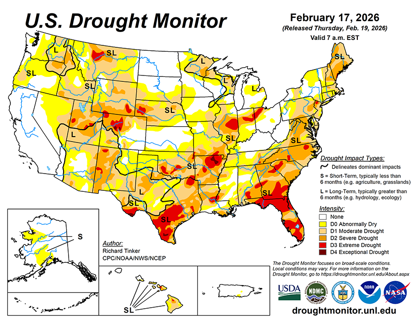
The heaviest precipitation over the next few days is forecast along and near part of the West Coast, with at least 2 inches expected across northwestern California, the southern Cascades, and the central and northern Sierra Nevada. Up to 7 inches may fall in isolated higher elevations, most or all of which would be snow. Meanwhile, moderate to heavy amounts (0.5 to 2.0 inches) are forecast across Washington and Oregon from the Cascades westward. Similar amounts are forecast for the northern Great Lakes, and most locations from the Deep South through central New England, with lesser amounts expected over much of the central and northern Carolinas. There is a lot of uncertainty in this area, depending on the development and track of an East Coast storm system that could affect the mid-Atlantic and lower Northeast over the weekend. Light to moderate totals are anticipated over a large part of the interior West, including the Great Basin, much of the northern Intermountain West, and the higher elevations across the Rockies. Several tenths of an inch are possible across the lower Great Lakes, middle and lower Ohio Valley, and the east side of the lower Mississippi Valley. Little or no precipitation is expected across the northern and southern Plains, southern Florida, and northern Maine. Above-normal temperatures are expected from the Southwest through most of the Plains, with many locations expected to average 5 to 11 deg. F above normal. In contrast, subnormal temperatures are forecast in the northernmost Plains, where daily highs could average as much as 9 deg. F below normal. Meanwhile, 5-day average anomalies are expected to range from -2 to -5 deg. F across northern California as well as the Ohio Valley and many locations farther east.
The 6- to 10-day outlook for February 24-28 depicts increased chances for below-normal precipitation across much of the southern tier of the contiguous U.S., from the extreme southern Rockies through the central Gulf Coast and most of Florida. Chances for abnormal dryness exceed 40 percent across most of Texas and some adjacent areas. Farther north, heavier than normal precipitation is at least nominally favored from the mid-Atlantic, southern Appalachians, central Plains, and Desert Southwest northward to the Canadian border. Chances for unusually unsettled weather exceed 60 percent across central and northern California, and top 50 percent central California northward across western Washington and Oregon, as well as the middle and lower Ohio Valley. In Alaska, drier than normal conditions are favored along western parts of the state while surplus amounts are more likely over eastern areas. Across Hawaii, above-normal amounts are marginally favored statewide. Meanwhile, warmer than normal weather is expected to dominate the contiguous 48 states from the Appalachians to the Intermountain West, with chances for significantly warmer than normal conditions topping 80 percent in western Texas. Areas somewhat favoring below-normal temperatures are restricted to the West Coast west of the Cascades, and over much of the Florida Peninsula. Considerably higher chances for unusually cold weather cover most of Alaska, reaching above 70 percent in southwestern parts of the state. In contrast, warmer than normal conditions are somewhat favored across Hawaii, especially across Kauai, Oahu, and the southern Big Island.


