National Current Conditions...
December 31, 2025 - January 6, 2026
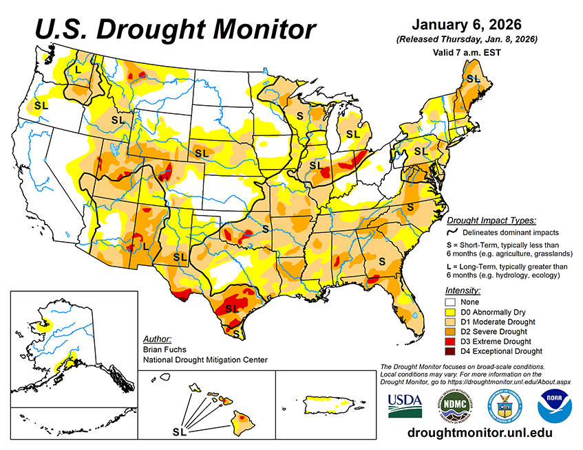
This week's U.S. Drought Monitor shows improvements to large parts of the West. However, winter precipitation falling as rain rather than snow has led to widespread snow drought. The Eastern Rockies, Plains, Midwest, South, and East have all seen degradations this week. As of January 6, 2026, 37.57% of the U.S. and Puerto Rico and 44.82% of the lower 48 states are in drought, according to the U.S. Drought Monitor.

This Week's Drought Summary…
The past week featured above-normal temperatures across much of the western half of the U.S. Areas west of the Mississippi River generally experienced near- to above-normal temperatures, with portions of the northern Rocky Mountains running 15–20°F above normal for the week. These warm conditions favored rain over snow, which is critical for winter water supply in the West, and many locations continue to experience a slow start to the snow season.
In contrast, cooler-than-normal temperatures dominated the Florida Peninsula, with departures of 5–10°F below normal across southern Florida. Below-normal temperatures were also widespread from the Upper Midwest into the Northeast and Mid-Atlantic, where departures of 5°F or more below normal were common. Parts of New England were particularly cold, with temperatures 10–15°F below normal.
Outside of the West, above-normal precipitation was limited to pockets of the Southeast, Florida, and the Upper Midwest. Much of the West recorded more than 100% of normal precipitation for the week, with large portions of California receiving over 200% of normal.


