National Current Conditions...

January 21, 2026 - January 27, 2026

Drought in the Lower 48 States decreased 2.2% since last week but increased 3.8% since last month.

This Week's Drought Summary…

Most precipitation across the contiguous United States fell in association with a large, impactful storm system that affected a broad area from the southernmost Rockies and the southern Plains eastward across a large part of the Mississippi and Ohio Valleys, the Southeast, and the Eastern Seaboard. Winter storm warnings at one point covered about one million square miles. Heavy to excessive amounts of snow, sleet, and freezing rain were widespread throughout the region. Numerous locations across Pennsylvania, New York, and New England recorded 1 to 2 feet of snow or snow and sleet. Elsewhere, totals reached as high as 17 inches in Ohio and West Virginia; 15 inches in Oklahoma, Missouri, Illinois, and Indiana; and 1 foot in Arkansas, Kentucky, Maryland, and Delaware. Intense sleet fell farther south, overlapping the southern sections of the heavy snow area. Sleet totals topped out near 7 inches in Arkansas, Louisiana, and North Carolina; near or slightly over 6 inches fell on scattered sites across Oklahoma, Texas, Louisiana, Mississippi, Tennessee, and Maryland; and localized amounts reached 4 inches in Texas, South Carolina, North Carolina, West Virginia, and Virginia. Freezing rain fell in abundance across portions of the South, and in some areas that experienced a changeover from sleet. States with at least one site reporting 1 inch thick ice accumulation included Oklahoma, Louisiana, Mississippi, Alabama, and South Carolina while peak amounts of 0.7 to 0.8 inch were reported in Texas, Kentucky, Tennessee, Georgia, Virginia, and West Virginia. Widespread power outages and tree damage was reported in many locations that received heavy freezing rain. Liquid-equivalent precipitation totals associated with this system exceeded an inch in parts of the southernmost Rockies, in a band from eastern Texas and western Arkansas eastward through Alabama, most of Tennessee and Kentucky, the central and northern Virginias, Maryland, Delaware, New Jersey, and in scattered locations across adjacent areas, including the Northeast. Scattered areas across the southern tier of the Lower-48 recorded over 3 inches of precipitation, including central Texas, southern Louisiana and adjacent Texas, and a fairly solid band from northeastern Texas through northern Louisiana, northern Mississippi, and northwestern Alabama. Up to 10 inches fell on one patch in southwestern Louisiana, and localized amounts exceeded 4 inches in northern Mississippi and a few other scattered areas.
However, despite the extensive coverage of impactful precipitation, the storm has not yet brought about broad areas of drought relief. Improvements were made where some of the heaviest liquid-equivalent precipitation fell, including a few places where it fell in frozen form. However, Arctic air has settled into the eastern states in the wake of the storm, and in many if not most areas, the water that could eventually help ease drought conditions was locked up in accumulated frozen precipitation, and can’t provide tangible improvements to drought impacts until it has melted. In the South, this may be only a matter of a few days, and relief was depicted more quickly there than farther north, especially in the northern tier of the East where temperatures may remain below freezing for extended periods of time.
Along the northwestern and southeastern edges of the winter storm, light to moderate precipitation was recorded, with totals ranging from a few tenths to nearly an inch over the western half of Texas and from much of Oklahoma northeastward through most of Missouri, Illinois, Michigan, Indiana, Ohio and the upper reaches of the Northeast. Similar amounts were noted to the south of the heaviest precipitation, generally across portions of the Carolinas, southeastern Georgia, Florida, and the immediate central Gulf Coast.
In other parts of the Lower-48, very little if any precipitation was recorded. The single widespread and extremely impactful winter storm was responsible for almost all of the precipitation observed this week.

Looking Ahead...

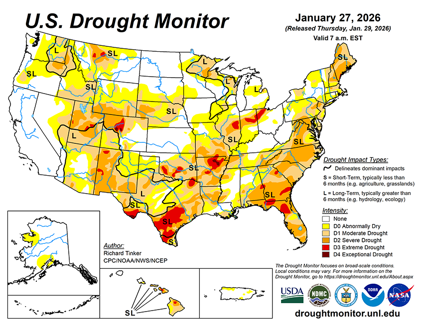
Not much precipitation is expected across the contiguous U.S. A strong but compact coastal low is expected to intensify rapidly off the Carolina coast. There is a great deal of uncertainty regarding the evolution of this system, exacerbated by the compact nature of the system, which means a small change in track could have big implications for precipitation amounts at any given location. The Carolinas and southern Virginia are the most likely regions to receive moderate to heavy precipitation, and given the much below normal temperatures in place, it will likely be mostly or entirely snow. Snow could affect a larger area surrounding this region, but odds for heavy snow drop moving away from the Carolinas and southern Virginia. Later, the strong low pressure system will head northeastward, possibly pushing moderate to heavy snow onto portions of the immediate Atlantic Coast from Maryland northward. In the areas most directly affected, amounts near or exceeding one inch (liquid equivalent) are expected, with several tenths of an inch possible a bit farther away from the storm. Moderate to heavy precipitation is also expected over the western half of Washington and adjacent Oregon. The Washington Cascades and far northwestern Washington are expecting 2.5 to 5.0 inches of precipitation, with totals ranging from near 1.0 to 2.5 inches in the rest of the area. Only light to locally moderate precipitation, if any is forecast elsewhere across the contiguous U.S. Several tenths to an inch may fall on northern Idaho, and a few tenths of an inch are forecast across some of the higher elevations of Wyoming and Colorado, parts of the northern Plains, and portions of the Florida Peninsula. Light amounts at best are expected elsewhere across most of the contiguous U.S. Meanwhile, the pattern featuring abnormally cold weather in the eastern half of the Lower-48 and unseasonably mild temperatures farther west. Subnormal temperatures are expected across a broad area from the central and southern Great Plains eastward and northeastward through the Eastern Seaboard outside northern New England. Temperatures are expected to average 10 or more degrees below normal in much of this area, with isolated sites in the Mid-Atlantic and southern Florida reaching 15 degrees below normal. Farther west, above-normal temperatures are expected to cover most areas from the High Plains to the West Coast. Temperatures are expected to average 10 to approaching 15 degrees above normal across the Great Basin, northern Intermountain West, and the central and northern sections of the Rockies and High Plains.
The 6- to 10-day outlook for February 3-7 depicts an eastward expansion of abnormal warmth into the middle of the Lower-48 while subnormal temperatures persist in most areas from the Lower Mississippi Valley, Lower Ohio Valley, and eastern Great Lakes to the Atlantic Coast, excepting northern New England. Odds for above-normal temperatures increase moving westward, with chances of at least 80 percent in place over parts of the northern High Plains and from the western Rockies to the Pacific Coast. Meanwhile, chances for subnormal temperatures top out above 70 percent across southern Florida, eastern North Carolina, and adjacent Virginia. Warm weather is favored across most of Alaska – especially southeastern sections – and throughout Hawaii. Wetter than normal conditions are also favored across the 49th and 50th states, but increased odds for surplus precipitation in the Lower-48 are limited to the southern Plains. Meanwhile, enhanced chances for subnormal precipitation covers the northern Plains and most areas from the Rockies to the Pacific Ocean. Chances for abnormal dryness exceed 60 percent across the Great Basin and the northern Intermountain West. Meanwhile, Chances for below-normal precipitation are slightly elevated along the Eastern Seaboard, though odds of 40 percent or higher are limited to a swath from central Florida through the eastern half of South Carolina.