National Current Conditions...

January 14, 2026 - January 20, 2026

Drought in the Lower 48 States increased 3.4% since last week and increased 8.5% since last month.

This Week's Drought Summary…

The Lower 48 States finally settled into a more tranquil weather pattern, as a ridge of high pressure settled across the West and a deep trough developed over the East. With many parts of the western U.S. reporting below-average snowpack for this time of year, the pattern change led to increasing concerns regarding Western water supply for next summer and beyond, despite robust precipitation in many areas during the first half of the winter wet season. Still, hydrologic signals were mixed, with California’s 154 primary intrastate reservoirs containing 25.9 million acre-feet of water (123% of the historic average) as 2026 began. Meanwhile, storage in the sprawling, multi-state Colorado River Basin stood at just under 17.3 million acre-feet (53% of average), reflecting long-term issues in part related to chronically elevated temperatures and a multi-decadal Southwestern drought.
Farther east, the Plains served as the transition zone between mild, dry weather in the West and increasingly cold conditions in the East. The Plains’ experienced dry weather, aside from wind-driven snow showers on the northern Plains, as well as an occasionally elevated wildfire threat. Elsewhere, areas from the Mississippi Valley eastward noted cold weather, accompanied by occasional rain and snow showers. Some of the heaviest snow fell the Great Lakes States, especially in squall-prone locations. Snow also fell along and near the Atlantic Seaboard, mainly on January 17-18. As colder air became more entrenched in the Midwest and East, drought changes that had been occurring quickly in recent weeks, either due to flash drought or active winter storms, became more muted, with drought effectively “frozen in place” by chilly, mostly dry conditions. During the second half of the drought-monitoring period, sub-0°F temperatures were commonly observed across the upper Midwest and neighboring regions.

Looking Ahead...

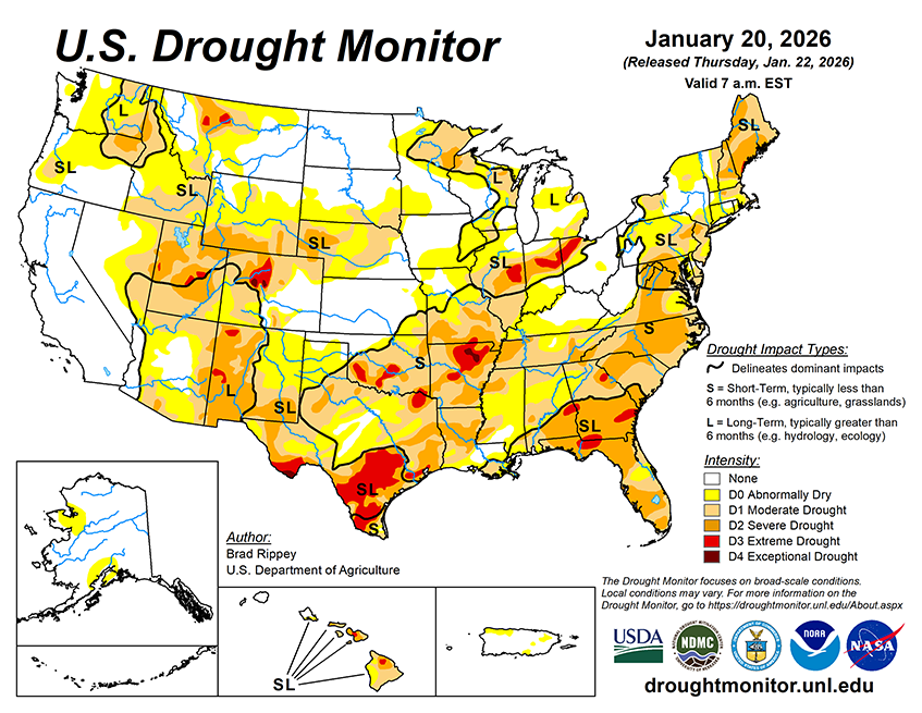
From January 23-26, an expansive and potentially dangerous winter storm will unfold from southern sections of the Rockies and Plains to the middle and southern Atlantic States, excluding areas along and near the Gulf Coast. Much of the South will face multiple weather hazards, including wintry precipitation (snow, sleet, or freezing rain), gusty winds, and unusually low temperatures. Wintry weather may extend at least as far south as central Texas and northern sections of Louisiana, Mississippi, Alabama, and Georgia. Post-storm temperatures should fall to 10°F or below along and north of a line from central Texas to northern Georgia, with particular concern for areas that lose electricity due to downed power lines from accumulations of ice and snow. Farther north, sub-0°F readings will be common as far south as the central Plains and the Ohio Valley. The storm is likely to have serious agricultural impacts, including significant stress on livestock due to exposure to cold, wind, wintry precipitation, or a combination of weather extremes. Temperatures could briefly plunge to -30°F or below from North Dakota into the upper Great Lakes region.
The NWS 6- to 10-day outlook for January 27 – 31 calls for the likelihood of below-normal temperatures throughout the eastern half of the U.S., while warmer-than-normal weather will prevail in the West. Meanwhile, near- or below-normal precipitation nearly nationwide should contrast with wetter-than-normal conditions in a few areas, including southern Florida and southern and coastal Texas.