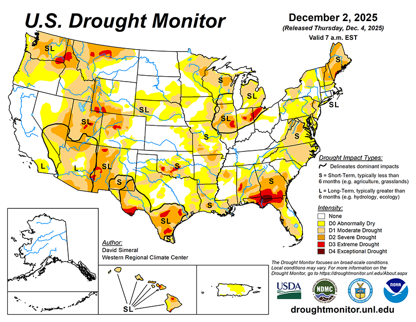
The NWS 7-day quantitative precipitation forecast calls for the heaviest rainfall (2 to 5 inches) to be along the central Gulf Coast, including southern Louisiana, southern Mississippi, southern Alabama, and the western Florida Panhandle, while 1 to 4 inches is expected in southern Georgia and areas of coastal South Carolina. The southern extent of the Mid-Atlantic coast is forecast to receive 1 to 3 inches, while New England is expected to have totals less than 1 inch. In the Pacific Northwest, 2 to 7+ inches (liquid) of precipitation is expected across western portions of Washington and Oregon, while the Northern Rockies—including northern Idaho, western Montana, and western Wyoming—are forecast to receive liquid totals ranging from 1 to 3 inches. These values represent liquid precipitation and may fall as rain or snow; actual snowfall amounts will vary depending on temperature and snow-to-liquid ratios. Meanwhile, much of the Intermountain West, Desert Southwest, and the central and southern Great Basin is expected to remain mostly dry, although northern portions of Utah and Colorado are forecasted to observe totals ranging from 0.25 to 2.0 inches. Across the Plains and Midwest, precipitation totals are expected to be less than 0.5 inch.
The 6–10-day temperature outlook (valid December 9 –13, 2025) calls for above-normal temperatures across the western U.S., much of the Plains, and Texas, with the highest probabilities centered over the Far West and Great Basin. Below-normal temperatures are favored across the eastern United States, with the highest probabilities in the Northeast and portions of the northern Mid-Atlantic and Great Lakes. Near-normal temperatures are expected across a narrow swath extending from the Lower Mississippi Valley through the eastern portions of the Dakotas. In terms of precipitation, the 6–10-day outlook calls for below-normal precipitation across the southern half of the continental United States, including California, Great Basin, southern half of the Intermountain West, South, and much of the Southeast. Above-normal precipitation is forecasted for much of the northern tier of the continental U.S., including the Pacific Northwest, Northern Plains, Upper Midwest, and the Northeast. Near-normal precipitation is expected across the Lower Midwest and southern Florida.