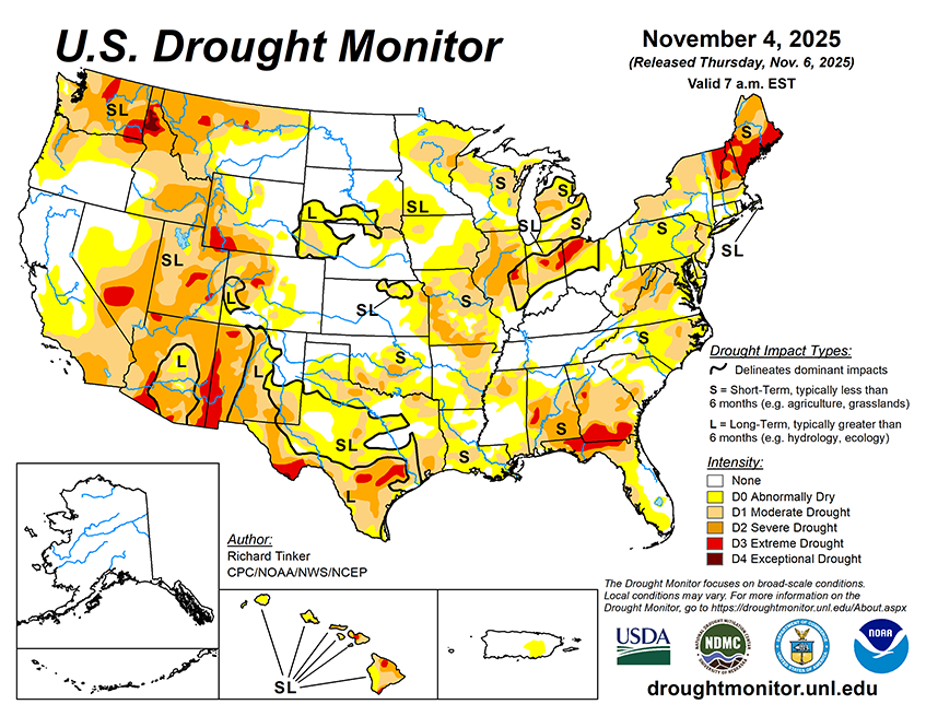
Over the next 5 days (through November 10), the Pacific Northwest is expected to remain relatively wet. Between 3 and 6 inches are anticipated in parts of the Washington and northern Oregon Cascades and far northwestern Washington. Generally 2 to 3 inches are forecast through the rest of the central and northern Cascades, most of coastal Washington, and coastal areas in northwestern Oregon and northwestern California. Elsewhere, moderate to locally heavy precipitation (1 to 2 inches) is anticipated in the remaining areas from northern California to the Canadian Border. Over much of the northern Rockies, in southern Michigan, to the lee of Lake Erie, across northern New York, and over parts of New England. Totals ranging from a few tenths of an inch to about an inch are anticipated across the northern Intermountain West, higher elevations of western Wyoming, isolated parts of the northern Great Plains, portions of the Midwest, the east half of the Great Lakes, most of the Appalachians, the middle and upper Ohio Valley, the central Gulf Coast states, much of the Northeast, and southeastern Florida. Other locations are expected to receive a few tenths of an inch at best, with little or none anticipated in the South Atlantic Coastal Plain, most of interior Florida, the Lower Mississippi Valley, and from the central and southern Great Plains westward into California. Temperatures are forecast to average warmer than normal in the West and cooler than normal in the East. A shot of cold air – the coldest of the season so far – should push through the East early next week. It will not linger for long, but on one or two nights temperatures could approach freezing as far south as the central Gulf Coast, and readings in the 50’s deg. F may reach into the southern Florida Peninsula. For the 5 days overall, high temperatures are expected to average 5 to 8 deg. F below normal from the Great Lakes and Midwest southeastward into northern Florida. In contrast, daily highs from the High Plains to the Pacific Coast should average 5 to 12 deg. F above normal, with the largest departures expected in parts of the Great Basin, near the California/Oregon border, and over the northernmost Rockies.
The 6- to 10-day outlook from the Climate Prediction Center for November 11-15 favors subnormal precipitation for most areas from the Great Plains to the Atlantic Coast, except along the northern tier of the region. Odds for unusual dryness exceed 50 percent from the Lower Mississippi and Ohio Valleys eastward through the South Atlantic States outside southern Florida. Abnormally wet weather is favored from the High Plains to the Pacific Coast, with chances for unusually heavy precipitation exceeding 60 percent across central and southwestern California. Wet weather is also somewhat favored through Hawaii and over most of Alaska. Temperatures are expected to average below normal in the East from the lower Great Lakes, Middle Ohio Valley, and central Gulf Coast eastward to the Atlantic Coast. The likelihood for subnormal temperatures exceeds 70 percent from northern Florida northward along the Coastal Plain into southern New England. From roughly the Mississippi River to the Pacific Coast, warmer than normal weather is favored, with odds topping 70 percent across a broad area covering most of the central and southern Rockies and High Plains. Warm weather is also expected over most of Alaska and across Hawaii.