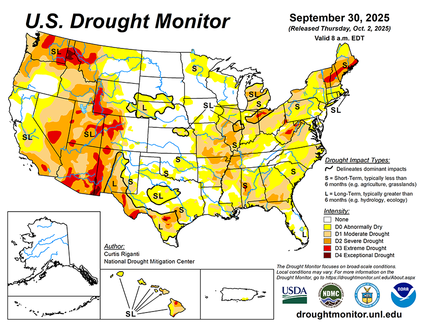
National Current Conditions unavailable due to U.S. Government Shutdown...

This Week's Drought Summary…

This week, widespread rains fell from parts of southern Missouri and Arkansas northeastward into the northeast U.S. Amounts of 1-2 inches were common, and locally higher amounts fell, especially in northwest and southern Arkansas, parts of Tennessee and Kentucky and in eastern New York and southern New England. Many of the areas which received these rains were experiencing drought or abnormal dryness. For some, the rain provided enough relief to improve conditions, while for others, especially in south-central Missouri and northern Arkansas and in New England, heavier rains were only enough to halt recent worsening trends. Very dry weather continued in northern parts of Illinois, Indiana, Ohio, most of Lower Michigan and the northern Great Plains and Upper Midwest, leading to some deterioration in areas that have remained dry recently. Recent precipitation in parts of the High Plains and West led to improvements for the northern Colorado Front Range into the southeast half of Wyoming, and in portions of New Mexico, Arizona, Nevada and Oregon. Continual dry weather led to worsening conditions in northern Montana and adjacent western North Dakota, where abnormal dryness and moderate and severe drought expanded in coverage. Widespread flash drought conditions occurred this week across parts of the far south-central and Southeast U.S. Impacts were acute in portions of southern Georgia, where the peanut crop was suffering as a result of the rapid drying. While precipitation amounts varied widely, above-normal temperatures were standard across most of the U.S., except for parts of Arizona and New Mexico. In most of the rest of the U.S., temperatures were between 2-6 degrees above normal, while the northern Great Plains, Upper Midwest and Northeast baked in September heat that generally ranged from 6-10 degrees warmer than normal.


Looking Ahead...

Between the evening of Wednesday, Oct. 1 and Monday, Oct. 6, the National Weather Service Weather Prediction Center is forecasting mostly dry weather across large portions of the Contiguous U.S., spanning from southern California east and northeast through the Ohio Valley, eastern Great Lakes and Northeast. Outside of the Southeast, precipitation amounts of at least 0.75 inches are confined to parts of the Sierra Nevada, northern Nevada, northern Utah, parts of Idaho, northern Wyoming, southern Montana, western South Dakota and central North Dakota. Heavier rain amounts are forecast in parts of southeast Louisiana and the Mississippi Gulf Coast, far southern South Carolina, far southeast Georgia and much of the Florida Peninsula. In the Florida Peninsula and far southeast Louisiana, rainfall amounts may exceed 4 inches.
Looking ahead to Oct. 7-11, forecasts from the National Weather Service Climate Prediction Center (CPC) strongly favor above-normal precipitation in the Southwest U.S., especially Arizona and New Mexico, while above-normal precipitation is moderately favored in parts of the central Great Plains, Upper Midwest and Florida Peninsula. The CPC forecast slightly favors below-normal precipitation in parts of the south-central U.S. and parts of the northern Pacific Coast. Most of the southwest, central and eastern U.S. are favored to see above-normal temperatures, alongside the far northwest. Portions of the West spanning California into central and eastern Montana may see near-normal temperatures.