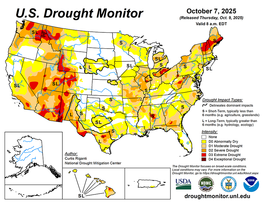
The NWS forecast covering the period from October 8 to October 13 calls for an inch or more of precipitation from northwest California northward through northwest Washington. The WPC is also forecasting areas west of the Continental Divide in New Mexico and Colorado, as well as much of Arizona and Utah, to receive over 1 inch of precipitation, with some areas in Arizona and southwest Colorado forecast to receive over 3 inches. Forecast precipitation amounts dwindle north of Utah, though portions of Idaho and Montana may receive a half inch or more during this period. Heavy rain amounts are possible from the east coast of Florida northwards through the Atlantic Coast to southern New England. As of the afternoon of Wednesday, October 8, the east coast of Florida and the coasts of North Carolina and Virginia, as well as the Delmarva Peninsula, New Jersey appear most in line to receive at least 1.5 inches of rain, with higher amounts possible. However, given the forecasted tight gradient in rainfall amounts, small shifts in the track of the storm system may significantly impact how much rain falls in any particular location along or near the East Coast. Meanwhile, across most of the Great Plains, Midwest and South, mostly dry weather is forecast.
Looking ahead to October 14-18, the National Weather Service Climate Prediction Center forecast favors warmer-than-normal weather across most of the central and eastern Contiguous U.S., especially in the southern Great Plains and Lower Mississippi River Valley. Colder-than-normal weather is favored across much of California, Nevada, Oregon, Idaho, Washington and western Montana. Above-normal precipitation is favored across most of the West (except for northwest Oregon and most of Washington) and into the northern half of the Great Plains and western Great Lakes states. Above-normal precipitation is slightly favored in most of New England, while below-normal precipitation is slightly favored in northwest Washington. Below-normal precipitation is favored in the south-central and southeast U.S., with a slight lean toward below-normal precipitation extending northward to Lake Erie. Above-normal temperatures are strongly favored in most of Alaska, with above-normal precipitation also favored across most of the state. In far southeast Alaska, near- or below-normal precipitation is more likely. Above-normal precipitation and warmer-than-normal temperatures are favored across Hawaii.