National Current Conditions...
September 3, 2025 - September 9, 2025
Conditions worsened in every region in the eastern half of the U.S., including the Northeast, Mid-Atlantic, South/Southeast, and Midwest. However, there were a few exceptions (e.g., eastern Kentucky).

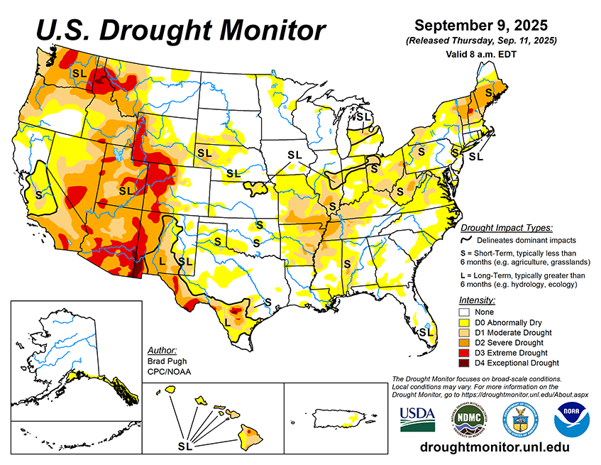
As of September 9, 2025, 30.11% of the U.S. and Puerto Rico and 35.90% of the lower 48 states are in drought, according to the U.S. Drought Monitor.

This Week's Drought Summary…
Abnormal dryness (D0) and short-term moderate (D1) to severe (D2) drought continued to expand across the Lower to Middle Mississippi Valley, Ohio Valley, Central Appalachians, Northeast, and Southeast. However, heavy precipitation (2 inches or more) resulted in a 1-category improvement to central and eastern portions of Kentucky and Tennessee. Enhanced moisture, associated with Hurricane Lorena in the East Pacific, led to locally heavy precipitation and drought improvements to parts of the Desert Southwest. Following a relatively wet week for this time of year, minor improvements were made to parts of Oregon. Elsewhere, little to no changes were warranted for the Pacific Northwest and California. A strong cold front for early September triggered heavy precipitation and drought improvements across New Mexico and the Rio Grande Valley of Texas. Much of the Central to Northern Great Plains and Upper Mississippi Valley remained drought-free. 7-day temperatures (September 2-8) averaged below-normal across most of the central and eastern U.S. with above-normal temperatures limited to the Pacific Northwest, Northern Intermountain West, Great Basin, and California. Widespread drought of varying intensity continued for Hawaii, while Alaska and Puerto Rico remained drought-free.