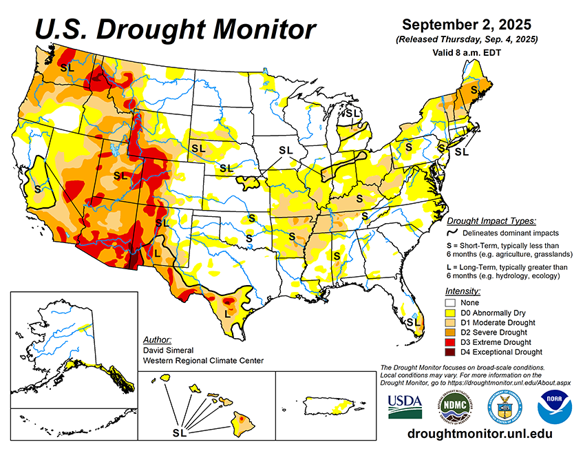
National Current Conditions... August 27, 2025 - September 2, 2025
Conditions worsened again from the Ohio Valley to the Central Mississippi River region. The Northeast and Mid-Atlantic also worsened. The West saw scattered monsoon-related improvements.

As of September 2, 2025, 29.13% of the U.S. and Puerto Rico and 34.72% of the lower 48 states are in drought, according to the U.S. Drought Monitor.

This Week's Drought Summary…
This U.S. Drought Monitor (USDM) week saw widespread degradation in drought-related conditions across areas of the Midwest, Mid-Atlantic, and Northeast where precipitation during the past 30-day period has been below normal. In these areas, rainfall deficits ranged from 3 to 5 inches with the largest deficits observed across areas of New England and Lower Midwest. Elsewhere, short-term dryness and drought impact reports from the agricultural sector led to degradations in isolated areas of the Southeast and South. For the week, most of the eastern half of the conterminous U.S. experienced unseasonably cooler temperatures, while temperatures out West were above normal, especially across the Pacific Northwest and Desert Southwest. In the West, conditions were generally dry, however, some isolated monsoon thunderstorm activity was observed in the Southwest, Sierra Nevada Range of California, Great Basin, and in the Rocky Mountains. In the Pacific Northwest, continued dryness as well as declining streamflow and soil moisture levels led to expansion of areas of exceptional drought in the Idaho Panhandle. In terms of reservoir storage in the West, California’s reservoirs continue to be at or above historical averages for the date (September 2), with the state’s two largest reservoirs, Lake Shasta and Lake Oroville, at 104% and 112% of average, respectively. In the Southwest, the U.S. Bureau of Reclamation is reporting (September 1) Lake Powell at 29% full (44% of average for the date), Lake Mead at 31% full (52%), and the total Colorado system (September 1) at 38% of capacity (compared to 44% of capacity the same time last year).


