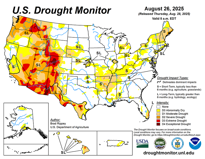
National Current Conditions... August 20, 2025 - August 26, 2025
Conditions worsened from the Ohio Valley (West Virginia, Ohio, Indiana, Illinois, Kentucky) to the Central/Lower Mississippi River regions (eastern Tennessee, Missouri, Arkansas, and Mississippi. Conditions were mixed in the Northeast, and remained similar to last week in the West.

As of August 26, 2025, 27.7% of the U.S. and Puerto Rico and 33.01% of the lower 48 states are in drought, according to the U.S. Drought Monitor.

This Week's Drought Summary…
On August 21, Hurricane Erin passed about 200 miles east of North Carolina’s Outer Banks, with minimal weather impacts aside from gusty winds along portions of the Atlantic Seaboard. A peak northerly wind gust to 43 mph was clocked on Cape Hatteras, North Carolina. More broadly, Erin resulted in an extended period of Atlantic coastal impacts, such as life-threatening surf and higher-than-normal tides. Meanwhile, patchy downpours maintained adequate to locally excessive soil moisture in much of the upper Midwest, while locally heavy showers dotted the central and southern Plains and the lower Southeast. However, mostly dry weather in many other areas across the central and eastern U.S. led to declining topsoil moisture reserves, especially where combined with late-summer heat. Cooler air arrived, however, late in the drought-monitoring period, starting in the North and soon reaching all areas east of the Rockies but the northern High Plains and the Deep South. Meanwhile in the West, hot, mostly dry weather prevailed until late in the period, when shower activity increased and began to spread northward.


