National Current Conditions... August 13, 2025 - August 19, 2025
The Northeast and Central/Lower Mississippi River regions have both seen dryness expand and drought develop. Out West, drought conditions went from bad to worse in parts of Idaho, Wyoming, Colorado, Utah, Arizona, and New Mexico.

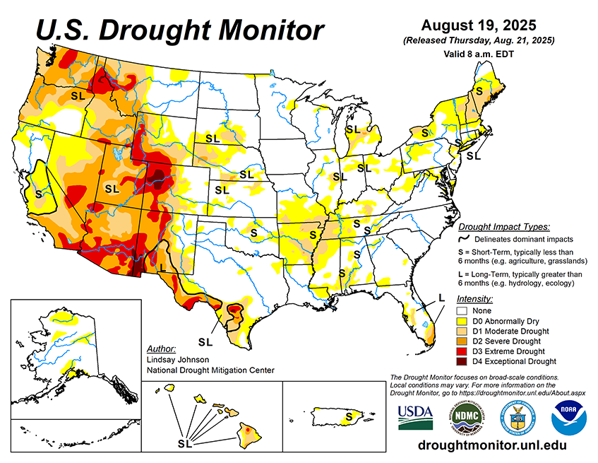
As of August 19, 2025, 26.77% of the U.S. and Puerto Rico and 31.92% of the lower 48 states are in drought, according to the U.S. Drought Monitor.

This Week's Drought Summary…
Between Aug. 13–19, 2025, dry and drought conditions were widespread, driven by hotter-than-average temperatures and below normal precipitation across much of the country. Temperatures across the country were mostly 1 to 5 degrees above normal, while isolated areas of North Dakota, Minnesota and California saw below-normal temperatures. Areas in the central High Plains and Midwest, Arkansas, along the Ohio River, central Pennsylvania and New York saw temperatures of 5 to 10 degrees above normal. Precipitation was mostly near to slightly below normal for much of the country. Along the Pacific Northwest coastline, rainfall was 1 to 3 inches above normal. The Southeast also saw areas of 1 to 3 inches above normal precipitation where thunderstorms dropped heavy precipitation. A series of storms brought above normal rainfall from South Dakota to Lake Michigan, with areas of eastern South Dakota, southern Minnesota and northeastern Illinois recording 2 to 5 inches. Storms that brought decent moisture saw improvements across the northern Intermountain West, central High Plains and the western Great Lakes region. In the West, severe to exceptional drought (D2–D4) remained widespread across California, Nevada, Arizona, and New Mexico, while hot, dry weather pushed drought to expand in Oregon, Washington, and Idaho. These conditions also fueled large wildfires, particularly in California and the Southwest, where dry vegetation and gusty winds created dangerous fire behavior. The High Plains also saw abnormal dryness and drought intensify across Nebraska, Kansas, and the Dakotas as above-normal temperatures and limited rainfall added stress to crops and rangeland. A few localized showers, however, offered minor improvements. In the South, scattered storms brought limited relief to parts of Texas and south-central Tennessee. Along the Tennessee and mid-Mississippi River valleys, flash drought conditions led to widespread intensification and expansion of abnormal dryness (D0) and moderate drought (D1)—particularly in southern Missouri, western Kentucky and Tennessee, northwestern Mississippi and Arkansas. Areas of the Midwest that received heavy rains saw steady or improved conditions in Minnesota, Wisconsin, and Iowa, while continued dryness led to worsening drought in Illinois, Indiana and Ohio. The Southeast saw mostly stable conditions, though moderate drought and abnormally dry areas persisted in Alabama, Georgia, and the Carolinas. Meanwhile, the Northeast continued to dry up, with the expansion of abnormal dryness (D0) and moderate drought (D2) across New England.


