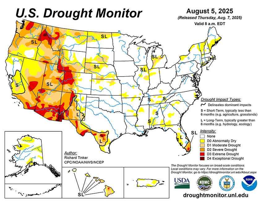
From August 7 to 11, an area of showers and thunderstorms off the Southeastern Coast may develop into a tropical system according to the National Hurricane Center, but this is far from certain. Any organized system is expected to remain off the East Coast, but early in the period the disorganized convection is expected to impact the South Atlantic Coastline. Generally 1 to locally over 3 inches of rain are forecast for coastal sections of South Carolina, Georgia, and northern Florida while similar amounts are forecast along the central and eastern Gulf Coast, and much of the Florida Peninsula. Between 1 and 3 inches are anticipated near a frontal system stretching from the Middle Mississippi Valley into the Great Lakes Region, and amounts in the lower part of that range are forecast in scattered parts of the central and northern Plains. Moderate amounts of several tenths to around an inch should fall in many areas from the Upper Mississippi Valley into the Northern Intermountain West, portions of the central Plains, and areas near the Southeastern and Gulf Coasts. Light precipitation is possible in parts of the central and eastern Four Corners States, the central Ohio Valley, the southern Appalachians, the mid-Atlantic, and upper New England. Other areas are expecting little if any precipitation. Meanwhile a cooler than normal but moderating air mass should allow temperatures to average near or slightly below normal in the Southeast and mid-Atlantic while daily highs should average a few degrees below normal in and around the northern High Plains. In most other locations, temperatures should average a little above normal as above-normal temperatures begin to slowly cover most of the Contiguous States. The greatest positive temperature departures are expected where above-normal temperatures have already settled in, specifically parts of the interior West and the Northeast, where highs will average 6 to 12 deg. F in spots.
The 6-10 day outlook (valid August 12-16, 2025) features significant uncertainty in the precipitation outlook. Odds for above-normal precipitation exceeding 40 percent across most of Alaska outside the northeast and southwest sections, and nowhere else. There are, however, fairly broad areas with slightly enhanced chances (33 to 40 percent) for wetter than normal wetter; specifically, the remainder of Alaska, the northern tier of the Contiguous 48 States, the Sonoran Desert, the eastern Great Plains, the Mississippi and Ohio Valleys, the Great Lakes Region, the upper Southeast, the mid-Atlantic, and inland sections of the Northeast and New England. Drier than normal conditions are slightly favored in the Great Basin and adjacent sections of the Rockies and Pacific Northwest. There is more certainty in the temperature forecast, with above-normal temperatures favored across a large part of the Contiguous States, and Hawaii. The best odds (over 70 percent) cover the Northeast and New England while the central West Coast, parts of the Four Corners States, the eastern Great Lakes, the mid-Atlantic, the coastal Southeast, and the Florida Peninsula have 60 to 70 percent chances for unusually high temperatures. Only Alaska and the northern High Plains are not areas where warmer than normal conditions are favored. In fact, subnormal temperatures are favored over most of Alaska, with odds topping 60 percent in northwestern parts of the state.