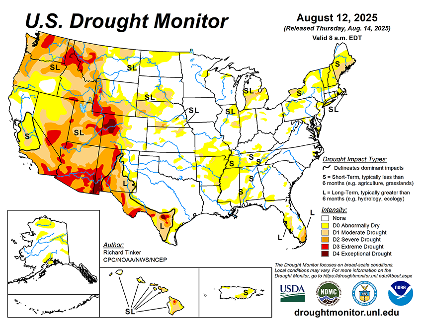
From August 14 to 18, heavy rain (2 to locally 5 inches) is forecast in the higher elevations and coastal sections of Washington and Oregon, and also from the eastern Upper Mississippi Valley through much of the Great Lakes. At least several tenths of an inch of rain, with isolated totals near 2 inches, in areas commonly affected by the late summer and autumn monsoon in the Southwest and higher elevations of central Colorado. Similar amounts are anticipated in the Lower Mississippi Valley, Gulf Coast states, interior Southeast, South Atlantic States, coastal Northeast, northern Plains, eastern Great Lakes, and lower elevations of Washington and western Oregon. Light to locally moderate amounts potentially approaching an inch are expected in the Ohio Valley and scattered locations across the Rockies. Meanwhile, little or no precipitation is forecast across California, the Great Basin, the northern Rockies, the central and southern Plains, and the Middle Mississippi Valley. The National Hurricane Center is forecasting Tropical Storm Erin to move northwestward while strengthening into a major hurricane by the end of the period. Most guidance keeps the system east of the Bahamas and the East Coast, but there is a lot of uncertainty in any forecast hurricane track 3 to 5 days in advance. Rough surf and high waves may impact the East Coast and the Bahamas even if the storm stays well out to sea. Generally above-normal should prevail from the Appalachians westward through central and northern sections of the Plains and Rockies, as well as the coastal Northeast. Temperatures should average closer to normal over the Southeast, the mid-Atlantic, and southern portions of the Plains and Rockies. Cooler than normal weather should be confined to the Great Basin and West Coast States.
The 6-10 day outlook (valid August 19-23, 2025) features significant uncertainty in the precipitation outlook. Odds for above-normal precipitation exceeding 40 percent are found in much of southern Arizona and the northern High Plains, and nowhere else. There are, however, fairly broad areas with slightly enhanced chances (33 to 40 percent) for wetter than normal wetter; specifically, from the portions of the Southwest typically affected by the late summer and autumn monsoon through the central and northern High Plains, and the northern Great Plains. Similar odds favoring above-normal precipitation also prevail across the southern Great Plains, the Lower Mississippi Valley, the interior Southeast, the Carolinas, the mid-Atlantic, and the coastal Northeast. Wetter than normal weather is also slightly favored across the northern half of Alaska. Meanwhile, odds lean towards below-normal rainfall in the Northwest and the northern Intermountain West, the Great Lakes, and the St. Lawrence Valley and adjacent New England. Drier than normal conditions are also favored along the southern tier of Alaska while near-normal amounts are expected across Hawaii. Meanwhile, warmer than normal weather is favored over the western half and southeastern quarter of the Contiguous United States, with odds reaching 60 to 80 percent in the central and northern High Plains, the Rockies, and the Florida Peninsula. Unusually warm weather is also favored across the southern half of Alaska, and Hawaii. Subnormal temperatures are favored over the eastern Great Lakes, mid-Atlantic, and Northeast.