National Current Conditions... June 25th thru July 1st

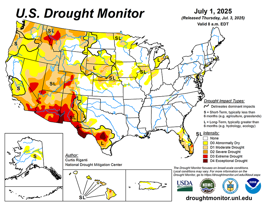
The Pacific Northwest saw drought and dryness worsen again, this time in Washington and Idaho. The Rockies worsened too (Montana, Wyoming, Utah, Colorado). Meanwhile, New Mexico and West Texas saw improvements with a wet start to monsoon season. Conditions also improved in the Central Plains and Florida. For the Northern Plains, Midwest, Alaska, and Hawaii, this week brought a mix of improvements and degradations.
As of July 1, 2025, 27.30% of the U.S. and Puerto Rico and 32.39% of the lower 48 states are in drought, according to the U.S. Drought Monitor.

This Week's Drought Summary…
Over the past week, scattered heavy rains fell over parts of the central Great Plains and Upper Midwest. Rain amounts were especially heavy in parts of Nebraska and Minnesota, where locally 8 or more inches of rain fell. These rains helped to alleviate drought and abnormal dryness in some areas. A few areas of the Dakotas, Minnesota, Indiana and Illinois that missed heavier rains saw localized degradations. Heavy monsoonal rain and thunderstorms also occurred in parts of west Texas and New Mexico, leading to some improvements to ongoing drought and abnormal dryness there. Meanwhile, most areas west of the Continental Divide remained dry or mostly dry. This continued dry weather led to further degradation in drought and abnormal dryness, especially in the Northwest, where severe and extreme drought developed or expanded in coverage. Conditions in the Southeast and central Gulf Coast were mostly quiet this week, though a few areas in east Tennessee and southern Louisiana saw localized abnormal dryness develop given short-term precipitation deficits and declining soil moisture. Heavier rains fell across parts of Florida, leading to some reduction in drought and abnormal dryness coverage in the Florida Peninsula. Well-above-normal temperatures occurred in the Ohio Valley, Mid-Atlantic and Lower Great Lakes regions, where temperatures ranging from 4-8 degrees above normal, and locally 10 degrees hotter than normal, were common. The Northwest was also warmer than normal this week, with most areas checking in with warm anomalies of 2-6 degrees. Southeast New Mexico and west Texas finished the week 2-8 degrees cooler than normal owing to rain and clouds from the North American Monsoon, which became much more active this week.


