National Current Conditions... July 16th thru July 22nd

Monsoonal moisture improved drought a bit in the Southwest, while the Northwest continues to worsen. Dryness has popped up and expanded in the Southeast, and the Plains and Midwest saw a mix of improvements and degradations.
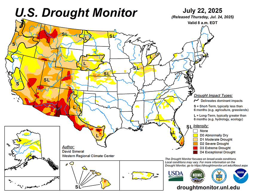
As of July 22, 2025, 26.31% of the U.S. and Puerto Rico and 31.38% of the lower 48 states are in drought, according to the U.S. Drought Monitor.

This Week's Drought Summary…
This U.S. Drought Monitor (USDM) week saw improvement in drought-related conditions across areas of the Southeast, South, Midwest, central and northern Plains, Intermountain West, and Desert Southwest, where short-term precipitation accumulations (past 30-day period) have helped to improve drought-related conditions. For the week, the most significant rainfall accumulations were observed across northern Kansas and areas of the Midwest including Missouri, Iowa, Illinois, and Indiana where accumulations ranged from 3 to 10+ inches, with the highest accumulations observed in northeastern Kansas. On the map, improving conditions over the past 30 to 60 days led to reduction in areas of drought in the Plains states, Kansas to North Dakota, as well as across drought-affected areas across the Midwest. Elsewhere, short-term dryness led to widespread expansion of areas of Abnormally Dry (D0) across the Southeast states including the Carolinas, Georgia, Alabama, and the Florida Panhandle. In the South, drought conditions continued to improve in Texas, including in the Trans-Pecos region in western Texas where short and mid-term composite drought indicators are showing improving conditions in terms of precipitation, soil moisture, and vegetation health. In the West, conditions were generally dry regionally, however, some isolated monsoon thunderstorms provided a much-needed boost in moisture (2 to 3 inch accumulations during the past week) to drought-affected areas of east-central and southeastern Arizona as well as lesser accumulations observed in central and northern Arizona. In terms of reservoir storage in the West, California’s reservoirs continue to be at or above historical averages for the date (July 22), with the state’s two largest reservoirs, Lake Shasta and Lake Oroville, at 105% and 117% of average, respectively. In the Southwest, the U.S. Bureau of Reclamation is reporting (July 21) Lake Powell at 31% full (47% of average for the date), Lake Mead at 31% full (52%), and the total Colorado system (July 20) at 39% of capacity (compared to 45% of capacity the same time last year).


