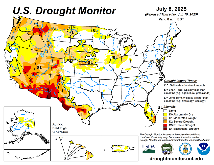
National Current Conditions... July 2nd thru July 8th

The Northwest, California, and Illinois saw large areas worsen this past week. Meanwhile, there were significant drought improvements in Montana, Nebraska, Minnesota, Florida, and Texas (where regions that were in Exceptional Drought [D4] experienced catastrophic flooding).
As of July 8, 2025, 26.25% of the U.S. and Puerto Rico and 31.07% of the lower 48 states are in drought, according to the U.S. Drought Monitor.

This Week's Drought Summary…
Drought coverage and intensity continued its decline throughout the Great Plains since the spring with additional heavy rainfall during the first week of July. Despite the extremely heavy rainfall and flash flooding this past week, long-term drought dating back multiple years remains across south-central Texas. Improving drought conditions were made to parts of New Mexico, southwestern Colorado, and Arizona, while drought expanded and intensified across the Pacific Northwest and Northern Intermountain West. Much of the Corn Belt and Midwest remains drought-free, but a continued lack of adequate precipitation led to worsening drought for northern Illinois. Following another week of summertime thunderstorms with heavy rainfall, drought ended for most of the central to southwestern Florida Peninsula. Nearly all of the East, Ohio and Tennessee Valleys, and Lower Mississippi Valley are drought-free. 7-day temperatures (July 1-7), averaged 2 to 4 degrees F above normal across the Pacific Northwest, Northern Great Plains, Midwest, and New England. Cooler-than-normal temperatures were limited to the Southern Great Plains and portions of the Southwest. Parts of northwestern Alaska and the Yukon River Valley are designated with short-term drought, while drought of varying intensity continues for Hawaii. Although Puerto Rico currently remains drought-free, short-term precipitation deficits have increased.


