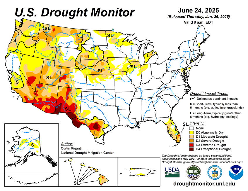
National Current Conditions... June 18th thru June 24th

The Pacific Northwest and Nevada saw large-scale degradations this past week, as did parts of the Rockies. The eastern half of the Lower 48 remains mostly drought-free, but small areas did worsen in the Midwest and Florida.
As of June 24, 2025, 25.83% of the U.S. and Puerto Rico and 30.66% of the lower 48 states are in drought, according to the U.S. Drought Monitor.

This Week's Drought Summary…
This week, widespread degradations occurred in the Northwest United States, where despite slightly cooler and wetter conditions this week, rapid drying continued to be a problem. In the central Great Plains and Midwest, scattered heavier rains led to improving drought or dryness conditions in some areas, especially in northern Missouri and Iowa, while some others who missed out on the heavier rains saw degrading conditions amid hotter-than-normal temperatures. In Florida, a mix of localized improvements and degradations occurred; scattered heavy rains improved the situation for some, while other areas that missed the heavy rain saw short- and long-term precipitation deficits grow amid worsening fire danger. After recent heavy rain, a small area west of Baltimore saw improvement to long-term moderate drought, while the most of the rest of the Northeast remained free of drought or abnormal dryness, with a small area of long-term moderate drought on Cape Cod continuing this week. A mix of improvements and degradations occurred in Texas following heavier rains last week in the south-central part of the state but drier weather in the Midland-Odessa area this week. Localized improvements occurred in areas of heavy rainfall on the eastern plains of New Mexico. Please note that any rain that fell from mid-Tuesday morning onward will be considered in next week’s map
In Alaska, short-term abnormal dryness and moderate drought developed and expanded in parts of central Alaska, where short-term precipitation deficits built and fire danger increased.
In Hawaii, localized improvements and degradations occurred after an overall drier week with trade-wind showers on the windward sides of the islands.
In Puerto Rico, abnormal dryness developed along the northwest and south-central coasts where short-term precipitation deficits grew amid crop stress and decreasing groundwater levels.


