National Current Conditions... June 4th thru June 10th

The Southwest and California/Nevada saw mostly improvements due to unusual early June moisture. The Central Rockies, Plains, and Midwest saw a mix of degradations and improvements. The Northwest into Montana was the only region where drought only worsened.
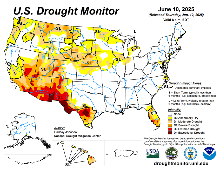
As of June 10, 2025, 25.12% of the U.S. and Puerto Rico and 29.91% of the lower 48 states are in drought, according to the U.S. Drought Monitor.

This Week's Drought Summary…
This week brought sharp weather contrasts across the U.S. The central Plains were 5 to 10 degrees cooler than normal, while the Pacific Northwest was 5 to 10 degrees warmer than average. A broad stretch from Texas through the Midwest to the Northeast received well above-normal rainfall, helping to ease drought conditions, while much of the West, northern High Plains and Florida remained dry, with many areas receiving just 5 to 25 percent of normal precipitation. These patterns led to widespread drought improvements across the High Plains, Midwest, South, and Northeast, particularly from northern Texas to southern Illinois, where 1 to 3 inches of rain reduced short-term dryness. Kansas, Nebraska, and eastern Colorado saw significant gains, while drought worsened in north-central Kansas, northwestern Colorado, and western Wyoming. Southwestern South Dakota and eastern Wyoming also improved. In the Midwest, drought eased in Missouri, Illinois, Indiana, and Michigan, but degraded in northern Minnesota and eastern Iowa. The Southwest benefited from rare early June rainfall and an unusually wet spring, with Arizona, southern Utah, southern Nevada, and parts of California improving after receiving 4 to 8 times their typical rainfall. New Mexico saw minor improvements in the southeast but stayed dry elsewhere. In the West, drought continued to worsen in Montana, northern Utah, and southeastern Wyoming due to ongoing dryness and low snowpack. Conditions in the Northwest are quickly degrading with well below-normal precipitation. The Southeast had mixed results—southern Georgia, the Carolinas and northeast Florida, and the Panhandle improved, while southern Florida remained dry. The Northeast continued its gradual recovery with steady rain. Alaska saw no changes, Puerto Rico remained drought-free, and Hawaii experienced mostly minor degradations.


