National Current Conditions... May 28th thru June 3rd

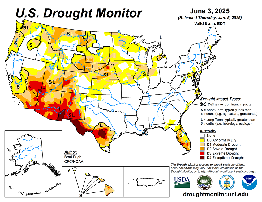
Increased precipitation this week brought drought improvements to much the Four Corners region (except Utah). But extreme to Exceptional Drought (D3–D4) remains. Elsewhere, drought improved across much of the Plains and Eastern U.S., but worsened in parts of the Midwest and Pacific Northwest.
As of June 3, 2025, 24.86% of the U.S. and Puerto Rico and 29.58% of the lower 48 states are in drought, according to the U.S. Drought Monitor.

This Week's Drought Summary…
Drought coverage and intensity continued its overall decreasing trend this spring across the Great Plains. To the east across southern Iowa, northern Illinois, and northern Missouri, drought expanded with little to no precipitation from May 27 to June 2. The Desert Southwest had an unusual wet start to June as a low pressure system, interacting with enhanced moisture from Tropical Storm Alvin in the East Pacific, resulted in locally heavy rainfall and a 1-category improvement to parts of Arizona. A wetter-than-normal May brought an end to drought throughout much of the Northeast. The rainy season is well underway across Florida and heavy rainfall this past week led to improvements across the central to southern Florida Peninsula. 7-day temperatures (May 27-June 2) averaged below-normal across most of the eastern and central U.S., while above-normal temperatures prevailed for the West. Alaska and Puerto Rico are drought-free, while drought of varying intensity continues for parts of Hawaii.


