National Current Conditions... May 14th thru 20th

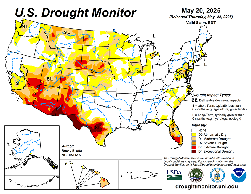
This week brought major improvements for the northern Plains and the Eastern U.S. from Maine to Florida. The Upper Midwest saw areas of degradation, as did the Southwest, where areas worsened for the 19th straight week.
As of May 20, 2025, 26.582% of the U.S. and Puerto Rico and 31.65% of the lower 48 states are in drought, according to the U.S. Drought Monitor.

This Week's Drought Summary…
This week, widespread precipitation impacted much of the U.S., with heavier amounts (exceeding 1 inch) observed from the northern Rockies eastward to the East Coast, and in portions of the Pacific Northwest, Hawaii, and southern Alaska. Specifically, much of the High Plains reported 2 to 10 inches of rain, while similar totals (2 to 8 inches) were seen across parts of the South, Midwest, and along the East Coast. This above-normal precipitation supported drought improvements across large portions of the High Plains and Northeast, parts of the Midwest and Southeast, and smaller pockets of the West and South. Conversely, below-normal weekly precipitation occurred in parts of the western U.S., the Midwest, and Southeast, leading to the expansion or intensification of drought and abnormal dryness in western High Plains, eastern West, and parts of the Midwest and Southeast. Temperatures were above normal across much of the U.S. this week. The southern U.S., from Texas to Mississippi, saw temperatures up to 10 degrees F above normal. In contrast, below-normal temperatures, with departures up to 10 degrees F below normal, were observed across much of the West and western High Plains, with the largest departures noted in the Dakotas and interior West.


