National Current Conditions... May 21st thru 27th

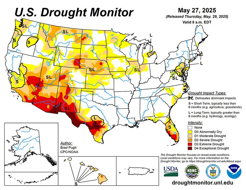
Early snowmelt continues to impact the West. Drought worsened in the Southwest for the 20th straight week (this time in Utah). The Midwest and Florida saw areas worsen too. The Plains and East mostly improved.
As of May 27, 2025, 26.08% of the U.S. and Puerto Rico and 31.05% of the lower 48 states are in drought, according to the U.S. Drought Monitor.

This Week's Drought Summary…
The wet May pattern continued to alleviate or bring an end to drought across the Northeast. Severe to extreme drought persists for central to south Florida although locally heavy showers fell across the east-central Florida Peninsula as the rainy season begins to ramp up. Widespread precipitation (2 inches or more) supported improvements to the Central and Southern Great Plains. During recent weeks, drought developed across portions of southwestern Iowa, northern Illinois, and northwestern Indiana. Short-term drought expanded across the Pacific Northwest and intensified for southern Utah and northwestern Colorado during mid to late May. From May 20-26, above-normal temperatures were limited to the southern tier of the contiguous U.S. 7-day temperatures averaged 4 to 10 degrees F below normal across the Northeast, Corn Belt, and Northern to Central Great Plains. Alaska and Puerto Rico are drought-free, while drought of varying intensity continues for parts of Hawaii.


