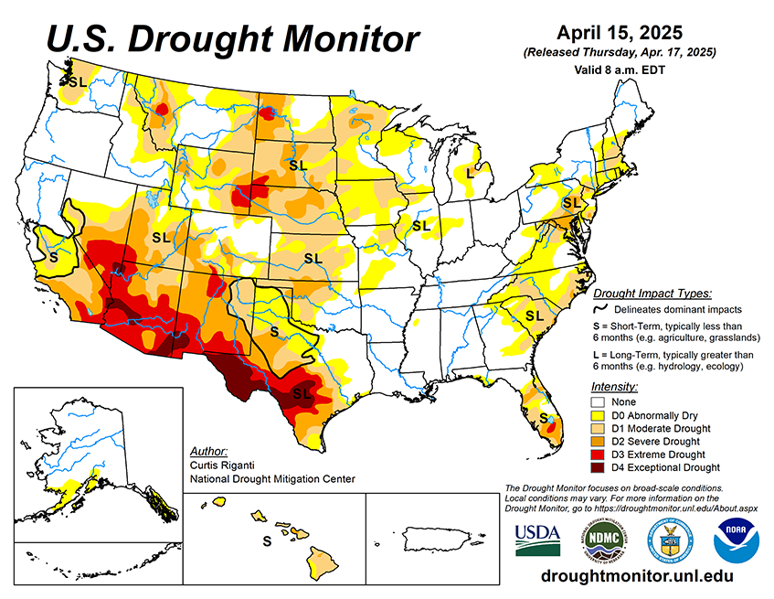
Between Wednesday, April 16 and the evening of Monday, April 21, the National Weather Service Weather Prediction Center is forecasting widespread heavy rainfall in parts of the central U.S., especially along east and south of the Interstate 44, 35 and 70 corridors in Oklahoma, Kansas, Missouri, Arkansas, Illinois and Indiana. Precipitation amounts may reach or exceed 3 inches from eastern Oklahoma northeast through St. Louis into eastern Illinois. The forecast calls for precipitation amounts from 0.25-1 inches in parts of the Rocky Mountains, with locally higher amounts possible, especially from far northern New Mexico north to southern Montana. Precipitation amounts from 0.5-1.25 inches, with localized higher amounts, are forecast from southeast Minnesota east through Wisconsin and Michigan. Farther east, weather along the Atlantic Coast is forecast to be mostly dry.
For the period from April 22-26, the National Weather Service Climate Prediction Center forecast favors above-normal precipitation in much of the central and southern U.S., especially in Oklahoma, Texas, Arkansas and Louisiana. Warmer-than-normal temperatures are also favored across most of the contiguous U.S., especially in the Southeast. Drier-than-normal weather is slightly favored in northwest California and coastal areas of Oregon and Washington.