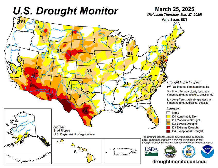
Drought-easing rain across southern Texas will gradually shift eastward along the Gulf Coast. Five-day rainfall totals could reach 2 to 8 inches or more across the western half of the Gulf Coast region, with higher totals leading to flooding in southern and coastal Texas. Meanwhile, active weather will also prevail in the vicinity of a nearly stationary front draped across the northern United States. The front will separate cold air to the north from warmth farther south, with accumulating snow expected during the weekend from parts of the northern Plains eastward into northern New England. Meanwhile, Midwestern 5-day rainfall could total 1 to 2 inches, accompanied at times by locally severe thunderstorms. Elsewhere, persistent low pressure near the northern Pacific Coast will maintain showery, unsettled conditions from the Northwest to the northern Rockies, while mostly dry weather will persist in the Southwest, despite a cooling trend.
The NWS 6- to 10-day outlook for April 1-5 calls for above-normal precipitation nearly nationwide, with northern and central California and the western Great Basin having the greatest likelihood of experiencing wet conditions. Elevated odds of near- or below-normal precipitation should be limited to southern Texas. Meanwhile, warmer-than-normal weather from the southern half of the Plains to the middle and southern Atlantic Coast should contrast with below-normal temperatures in the Far West and across the nation’s northern tier.