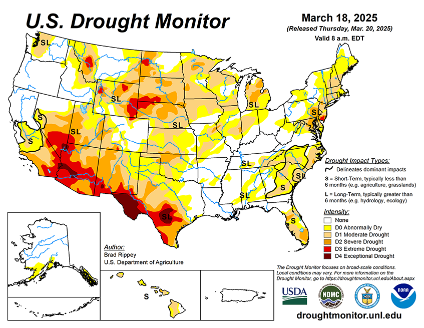
A low-pressure system moving into eastern Canada on Thursday will drag a cold front through the eastern United States. Locally severe thunderstorms may affect the middle Atlantic States on Thursday, followed by widespread Northeastern precipitation—rain and snow—lingering through Friday. Meanwhile, conditions across the nation’s mid-section will improve, following Wednesday’s blizzard from the central Plains into the upper Midwest and a widespread high-wind event. Still, an elevated wildfire threat will persist at least through Friday in parts of the south-central U.S., including the southern High Plains. Farther north, a pair of Pacific disturbances will move eastward near the Canadian border. The initial system will be fairly weak, but the second storm will intensify during the weekend across the northern Plains and upper Midwest. Impacts from the latter system, which will persist into early next week, should include late-season snow from the Cascades to the Great Lakes region; another round of windy weather across the nation’s mid-section; and potentially severe thunderstorms across portions of the South, East, and lower Midwest.
The NWS 6- to 10-day outlook for March 25-29 calls for the likelihood of near- or below-normal temperatures in most areas from the Mississippi River eastward, while warmer-than-normal weather will broadly prevail from the Pacific Coast to the Plains. Meanwhile, near- or above-normal precipitation across much of the country should contrast with drier-than-normal conditions in the Southeast, excluding southern Florida, and an area stretching from the Four Corners region to the central High Plains. Areas with the greatest likelihood of experiencing wetter-than-normal weather include southern Texas and the Pacific Northwest.