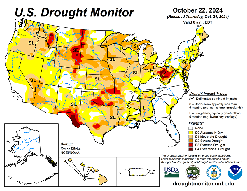
National Current Conditions: October 16, 2024 - October 22, 2024
The U.S. saw a huge expansion of drought for the third week in a row. Most of the degradation took place in the eastern Plains, Midwest, and South. The East Coast and Hawaii worsened too.
As of October 22, 2024, 41.89% of the U.S. and Puerto Rico and 49.97% of the lower 48 states are in drought, according to the U.S. Drought Monitor.
This Week's Drought Summary…
Precipitation fell across much of the U.S. over the past week, while heavier amounts were observed over parts of the Pacific Northwest and Southwest. Portions of New Mexico, Utah, Colorado and Washington reported rainfall totals between 3 to 5 inches above normal, while precipitation totals were below normal across much of the eastern U.S. Warmer-than-normal temperatures were observed across much of the U.S. this week. Temperature departures ranging between 6 to 15 degrees F above normal were observed from the northern Rockies to northern portions of the Midwest. Cooler-than-normal temperatures were observed from eastern portions of Texas to the Mid-Atlantic, and in parts of the Great Bains and Southwest. The Southeast observed temperatures between 3 to 9 degrees F below normal this week.

Looking Ahead...
During the next five days (October 22–26, 2024), The cold front crossing the Great Lakes and into the Northeast Wednesday into early Thursday will likely have just enough moisture and lift to produce some mainly light to moderate showers, while conditions should continue to remain dry and mostly sunny for areas farther to the south across the Mid-Atlantic and the Southeast U.S. Moisture is forecasted to return to the Pacific Northwest late this week into the weekend, with rain and high elevation northern Cascades snow could commence as early as late Thursday. Temperatures will feel more like September across areas from the central U.S. into the Northeast Tuesday into Wednesday, with highs running 10 to 20 degrees above average for late October and possibly even a little higher over parts of the Upper Midwest/northern Great Lakes on Tuesday. A cold front pushing rapidly eastward from the northern Plains will bring more seasonable conditions after midweek. From late week into the weekend, a building Western U.S. upper ridge that pushes eastward ahead of the Pacific storm system should promote a warming trend first over the Intermountain West and Rockies/western High Plains and then covering much of the central U.S. where many areas should see highs 10 to 20 degrees above normal. The West Coast states should be within a few degrees on either side of normal aside from a brief warmer period over parts of California around midweek.
The 6-10 day outlook (valid October 27–31, 2024) favors above-normal precipitation from parts of the Midwest to the West Coast, and across most of Alaska and Hawaii, with below-normal precipitation favored from the Tennessee Valley to the Northeast, as well as parts of the Southwest. Increased probabilities for above-normal temperatures are forecast for Hawaii and much of the contiguous U.S., while below-normal temperatures are likely across the state of Alaska and in the Pacific Northwest.


