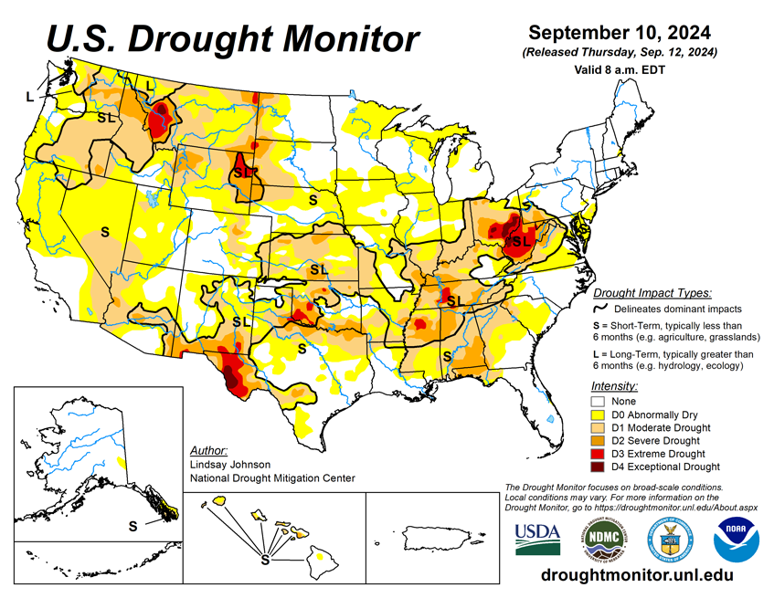
National Current Conditions: September 3, 2024 - September 10, 2024
Drought conditions worsened in every state in the Midwest, including more Exceptional Drought (D4) in Ohio. Tennessee and Oklahoma also saw large degradations. Hurricane Francine may help alleviate dry conditions in Ohio, the South, and Southeast.
As of September 10, 2024, 28.75% of the U.S. and Puerto Rico and 34.18% of the lower 48 states are in drought, according to the U.S. Drought Monitor.
This Week's Drought Summary…
There was a sharp difference in temperatures across the U.S. this week (Sep. 3 to Sep. 10). Temperatures in the West were above normal, whereas areas from Texas to Wisconsin and east saw temperatures of 3 to 9 degrees below normal. Very little precipitation fell, with Hurricane Francine providing most of it along the Gulf Coast. Overall, the central and eastern portions of the country saw continued deterioration, adding onto already expansive deterioration from last week. The Ohio River Basin continues to be the epicenter of the extremely dry conditions, though moderate and severe drought conditions are spreading through the southern Midwest into the Southeast. Improvements made along the Gulf Coast were primarily due to the well-above-normal precipitation brought by Hurricane Francine. There were some other areas of improvement in New Mexico, northeastern Arizona, eastern Utah, southern Wyoming and northwestern Montana. Areas of the West that have not seen any meaningful precipitation in a while are beginning to see dropping streamflows and drying soils.

Looking Ahead...
Over the next five days (September 11-16), precipitation is expected in the high elevation of Alberta Canada into Montana and Idaho, southern Arizona, and across the Gulf and southern Atlantic Coasts. Precipitation amounts of 2 to 5 inches are expected in Mississippi, northern Alabama, western Tennessee, the Florida Panhandle, and coasts of North and South Carolina.
The National Weather Service 6-10 day outlook heavily favors above-normal temperatures from the north-central to eastern Canadian border to Texas-Mexican border with Minnesota, Wisconsin, and Michigan 80 to 95% likely to see above normal temperatures. Conversely, southern California and Arizona are 70 to 90% likely to see below-normal temperatures. Shifting northward towards the western Canadian border, there is a change of at- or slightly below-normal temperatures. Hawaii and northern Alaska are leaning toward above-normal temperatures.
The National Weather Service 6-10 day outlook heavily favors above-normal precipitation in Montana and central Idaho, as well as the Atlantic Coast of Maryland, Virginia and North Carolina. Alaska and Hawaii are also leaning toward above-normal precipitation. Arizona, New Mexico, the Gulf Coast of Texas and Louisiana, and the Great Lakes region are leaning towards below-normal precipitation.


