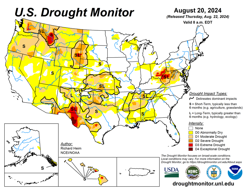
National Current Conditions: August 14th thru August 20th...
Extreme Drought (D3) was introduced to the Wyoming/South Dakota border and Ohio, and expanded in Montana, Texas, and West Virginia. The South/Southeast saw drought expand. Dryness and drought now cover almost all of the West.
As of August 20, 2024, 20.10% of the U.S. and Puerto Rico and 23.70% of the lower 48 states are in drought, according to the U.S. Drought Monitor.
This Week's Drought Summary…
A high-pressure ridge continued across the southern Plains during this U.S. Drought Monitor (USDM) week (August 14-20), bringing dry and very hot weather, especially to Texas. Pacific weather systems moving in the jet-stream flow brought above-normal precipitation to parts of the West Coast, the northern to central Rockies, and parts of the central to northern Plains, the Midwest, and Northeast. The rain was frequently hit-or-miss, with large parts of the Pacific Northwest to Plains, and Midwest to Northeast, receiving little to no precipitation. In addition, much of the Southwest, and southern Plains to Southeast, were drier than normal this week. An upper-level trough kept the Far West cooler than normal, while a large cold front brought cooler-than-normal temperatures to much of the Midwest to East Coast. The rain contracted drought and abnormal dryness in parts of the Rockies to central Plains, and a few parts of the Midwest and East Coast. But drought or abnormal dryness expanded or intensified in parts of the West that missed out on the precipitation, parts of the Great Plains, from the Tennessee Valley to central Gulf of Mexico coast, and parts of the Midwest to central Appalachians. The lack of rain continued to dry out soils across large parts of the West (especially the Pacific Northwest), in the southern Plains, the Lower Mississippi Valley, and central Appalachians. Numerous wildfires were burning across the West with some sparking up in the southern Plains and western High Plains. The most severe drought areas included the central Appalachians to Upper Ohio River Valley, the Rio Grande River Valley, eastern Wyoming, western Montana, and central Washington.

Looking Ahead...
In the two days since the Tuesday valid time of this USDM, scattered showers and thunderstorms brought areas of rain to parts of the Southwest, Pacific Northwest, and Plains, but the rest of the contiguous U.S. (CONUS) was mostly dry. For August 22-27, the upper-level ridge will slowly shift east, bringing warmer-than-normal temperatures to much of the CONUS between the Plains and Appalachians, while an upper-level trough will move into the West, bringing cooler-than-normal temperatures. An inch or more of rain is predicted for the Cascades, much of the Southwest (Four Corners States), and parts of the northern Rockies and central Plains. A stalled frontal boundary will bring an inch to locally 3 inches or more of rain to the Florida peninsula. Half an inch of precipitation is forecast for areas in the central to northern Plains, Middle to Upper Mississippi Valley, parts of New England, and northern parts of the West. Large parts of California and Nevada, the southern Plains, and Lower Mississippi Valley to Mid-Atlantic coast can expect little to no precipitation.
For much of the next 2 weeks, the ridge and trough pattern will continue to slowly move east. The Climate Prediction Center’s (CPC) 6-10 Day Outlook (valid August 27-31) and 8-14 Day Outlook (valid August 29-September 4) favor warmer-than-normal temperatures across the CONUS east of the Rockies, shifting to the East Coast as the ridge moves east. Odds favor below-normal temperatures over the Pacific Northwest and northern Rockies at first, then over the northern Plains as the trough moves east. The West Coast and southern tier states are likely to be warmer than normal through the period. Alaska may see cooler-than-normal temperatures in the southwest to warmer-than-normal temperatures in the northeast. Odds favor below-normal precipitation across parts of the Pacific Northwest and a large area centered over the Mid-Mississippi and Ohio Valleys, while above-normal precipitation is favored from the Southwest to northern Plains and parts of the Gulf Coast states, in the northern Rockies early in the period, and along the extreme East Coast late in the period. Most of Alaska could see wetter-than-normal conditions.


