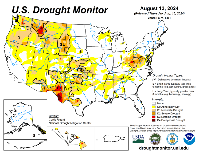
National Current Conditions: August 7, 2024 - August 13, 2024
This week, drought/dryness worsened in northern Texas and parts of the South. Extreme Drought (D3) was added to Washington and Hawaii. Meanwhile, Hurricane/Tropical Storm Debby improved conditions across the East. And many states, from Mid-Atlantic to the Great Plains, saw a mix of improvements and degradations.
As of August 13, 2024, 18.86% of the U.S. and Puerto Rico and 22.20% of the lower 48 states are in drought, according to the U.S. Drought Monitor.
This Week's Drought Summary…
Widespread improvements to ongoing areas of abnormal dryness or drought continued across parts of the eastern United States this week as the remnants of Hurricane Debby moved up the Atlantic Coast. Locally over 10 inches of rain fell in parts of the eastern Carolinas, while widespread rain amounts of at least an inch or two (locally much higher) were common through the eastern Mid-Atlantic and Northeast states. In these areas of heavier rains, one- or two-category improvements to ongoing drought or abnormal dryness were widespread. In eastern portions of the Midwest and across much of the Southeast and south-central United States (except for Oklahoma and the Texas Panhandle), primarily dry weather prevailed, mostly leading to unchanged or worsening drought or abnormal dryness. Swaths of heavy rain fell in parts of northwest Missouri, Oklahoma, northeast New Mexico, Colorado, and southeast Wyoming, leading to localized improvements in drought or abnormal dryness in these areas. The central and north-central United States were mostly cooler than normal this week, especially from Kansas north into the Dakotas and Minnesota, where temperatures from 6 to 12 degrees below normal were widespread. Near- or warmer-than-normal temperatures were common in the West, with the warmest temperatures of 3 to 9 degrees above normal primarily occurring in California, Nevada, and Utah. The eastern United States saw a mix of above- and below-normal temperatures, though most places finished the week within 3 degrees of normal.

Looking Ahead...
Through August 19, the National Weather Service Weather Prediction Center is forecasting mostly drier weather in the West, aside from some monsoonal moisture in Utah and Arizona and precipitation in northwest parts of Montana and Washington. Heavier rainfall amounts, locally exceeding an inch, are possible primarily east of the Missouri River and along and north of the Ohio River, covering parts of the Midwest and Northeast.
Looking ahead to the period from August 20-24, the National Weather Service Climate Prediction Center’s forecast favors below-normal temperatures in the Great Lakes, parts of the Upper Midwest and Northeast. South and west of here, warmer-than-normal temperatures are favored, especially from Arizona and New Mexico through Texas and the Gulf Coast. A small area of below-normal temperatures is favored from northern California through the western halves of Washington and Oregon. Wetter-than-normal weather is slightly favored along the Atlantic Coast, the northwest Great Plains, and the central and northern Rocky Mountains, while higher confidence for wetter-than-normal weather exists from northwest California through northwest Oregon and most of Washington. Warmer-than-normal weather is favored in Hawaii, and above-normal precipitation is favored on the Big Island, while equal chances for above- or below-normal precipitation exist elsewhere in Hawaii. In Alaska, warmer-than-normal temperatures are favored in the southeast, while cooler-than-normal temperatures are more likely in central and western portions of the state. The forecast favors drier-than-normal weather in the southeast half of Alaska, while central and northwest Alaska are more likely to receive above-normal precipitation.


