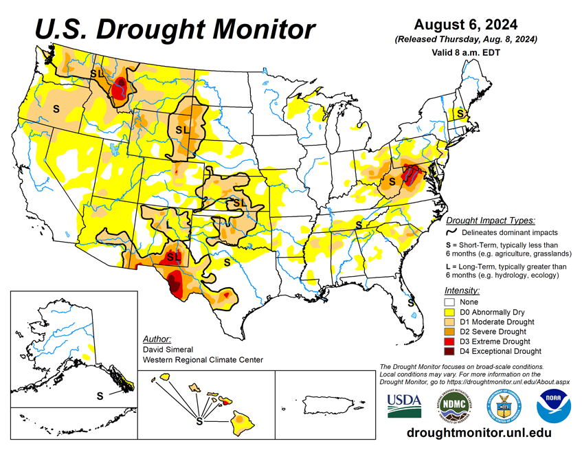
National Current Conditions: July 31, 2024 - August 6, 2024
Not surprisingly, every state in the Southeast saw improvements to drought /dryness this past week. However, every state in the West, Plains, and South, as well as Hawaii, saw conditions worsen. Some saw huge degradations (Utah), and others, small areas (North Dakota). The West is on the precipice of another region-wide drought: 32.7% of the western U.S. is in drought, with an additional 44.4% experiencing Abnormally Dry (D0) conditions.
As of August 6, 2024, 18.2% of the U.S. and Puerto Rico and 21.5% of the lower 48 states are in drought, according to the U.S. Drought Monitor.
This Week's Drought Summary…
This U.S. Drought Monitor (USDM) week saw widespread improvement in drought-related conditions on the map across areas of the Southeast, Mid-Atlantic, and in areas of the Midwest. Elsewhere, hot and dry conditions prevailed in areas of the West, Plains, and the South during the past 14-to-30-day period, leading to the expansion and intensification of drought on this week’s map with particular concern over the developing flash drought situation in areas of the Plains states. In the Southeast, Hurricane Debby (Category 1) made landfall Monday morning in Florida’s Big Bend region bringing a powerful storm surge, strong winds, torrential rains, and severe flooding to much of Florida’s Gulf Coast region from southwest Florida to the north-central region. Rainfall accumulations ranged from 2 to 20+ inches across affected areas with the heaviest accumulations logged in the greater Sarasota area. The impacts of Hurricane Debby, which weakened to a tropical storm shortly after making landfall, were also felt across the coastal zones and plains of Georgia and South Carolina with heavy rainfall (up to 15 inches according to radar estimates) and flooding. On the map, some drought-related improvements were made this week in the Carolinas in association with the remnant moisture from Hurricane Debby. However, it is noteworthy that this week’s drought depiction is representative of rainfall that fell until the data cutoff at 8 a.m. ET on Tuesday and additional improvements are expected on next week’s map.
Elsewhere, light-to-moderate rainfall accumulations (2 to 4 inches) were observed across areas of the Northeast, Midwest, and in isolated areas of the Northern Plains. Out West, some monsoon-related storm activity was observed in isolated areas of the Four Corners states and Nevada as well as some light shower activity in areas of Idaho and Montana. In terms of reservoir storage in areas of the West, California’s reservoirs continue to be near or above historical averages for the date (August 6) with the state’s two largest reservoirs (Lake Shasta and Lake Oroville) at 111% and 116% of their averages, respectively. In the Southwest, Lake Powell is currently 39% full (64% of typical storage level for the date) and Lake Mead is 33% full (53% of average) with the total Lower Colorado system 44% full as of August 5 (compared to 44% full at the same time last year), according to the U.S. Bureau of Reclamation. In Arizona, the Salt River Project is reporting the Salt River system reservoirs 85% full, the Verde River system 64% full, and the total reservoir system 83% full (compared to 91% full a year ago). In New Mexico, the state’s largest reservoir along the Rio Grande is currently 11% full (25% of average). In the Pacific Northwest, Washington’s Franklin D. Roosevelt Lake is 93% full (121% of average for the date) and Idaho’s American Falls Reservoir on the Snake River is 50% full (84% of average).

Looking Ahead...
The 7-Day Quantitative Precipitation Forecast (QPF) calls for moderate-to-heavy rainfall accumulations ranging from 4 to 10 inches across areas of the Eastern Seaboard from Georgia to New England. Lesser accumulations, ranging from 1 to 2 inches, are expected across areas of the Four Corners states as well as in the Central Plains and southwestern portion of the Midwest. Elsewhere in the conterminous U.S., generally dry conditions are forecasted.
The Climate Prediction Center (CPC) 6-10-day Outlook calls for a moderate-to-high probability of above-normal temperatures across much of the Four Corners States, much of the Plains states, the South, and Southeast. Conversely, below-normal temperatures are expected across much of California, eastern portions of the Midwest, and the Northeast. In terms of precipitation, there is a low-to-moderate probability of above-normal precipitation across the Pacific Northwest, Intermountain West, areas of the Desert Southwest, Central and Northern Plains, and in Alaska. Below-normal precipitation is expected across most of the South, Southeast, and western portions of the Great Basin.


