National Current Conditions: May 1, 2024 - May 8, 2024
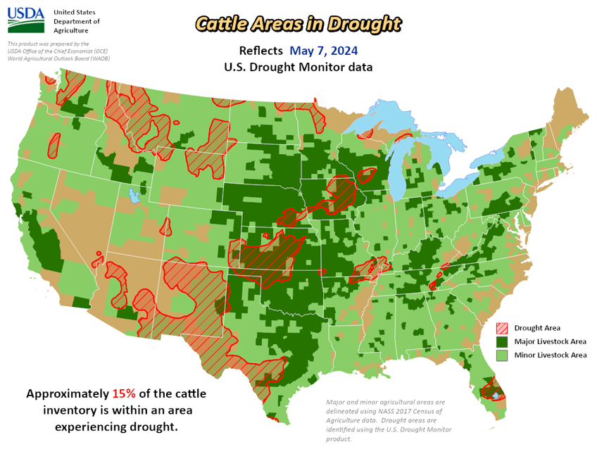
As of May 8, 2024, 12.66% of the U.S. and Puerto Rico and 15.08% of the lower 48 states are in drought, according to the U.S. Drought Monitor.


This Week's Drought Summary…
Heavy precipitation fell in western Oregon and adjacent southwest Washington and northwest California this week, and across large portions of the central U.S., as a series of storm systems caused continued bouts of severe thunderstorms and unfortunately included more significant tornadoes. The wet weather across portions of the Great Plains and Midwest led to either scattered or widespread improvements to ongoing drought or abnormal dryness, dependent on precipitation amounts, improvements to soil moisture and streamflow, and the degree of long-term dryness remaining in different locations. In Virginia, the Carolinas, and eastern Tennessee and Kentucky, heavy rains or lack thereof this week led to localized improvements or degradations in areas of short-term moderate drought or abnormal dryness. Very dry weather for the past few months led to increased fire danger in parts of the Florida Peninsula, and short-term moderate drought and abnormal dryness expanded in coverage. In southwest Kansas and adjacent eastern Colorado, mostly to the west of where this week’s showers and thunderstorms occurred, flash drought conditions continued and severe and moderate drought expanded in coverage. In Hawaii, wet weather continued on the windward sides of the islands, and some improvement to conditions occurred in Lanai and western Maui. Another wet week in Puerto Rico allowed for the removal of abnormal dryness from the northwest corner of the island.
Looking Ahead...
As of time of writing (the afternoon of May 8), precipitation forecasts from the National Weather Service Weather Prediction Center show mostly dry weather west of the Continental Divide within the contiguous U.S. through the evening of Monday, May 13. East of the Continental Divide, 0.5-1 inch of rain, with locally higher amounts, is forecast for portions of central and eastern Colorado, western Kansas, the Texas and Oklahoma panhandles, western Oklahoma and northeast New Mexico. Heavier rain amounts (locally exceeding 2 inches) are forecast from eastern Texas eastward across Louisiana, southern portions of Mississippi, Alabama and Georgia, and in Tennessee. Separate areas of forecasted rainfall above an inch are in north-central Iowa and from south-central New York to south-central Pennsylvania.
For May 14-18, the National Weather Service Climate Prediction Center forecast favors warmer-than-normal temperatures across most of the contiguous U.S., with the exceptions of portions of the south-central U.S. from Oklahoma to Tennessee and in the northwest half of Washington. Except for far northeast Alaska, the forecast favors colder-than-normal weather in most of Alaska, especially southwest, south-central and southeast Alaska. Near-normal temperatures are most likely in Hawaii. Precipitation forecasts in the contiguous U.S. favor near- or above-normal precipitation across most areas, except for the Pacific Northwest and a small part of southwest Texas. The highest confidence for wetter-than-normal weather is in the Southeast region. Wetter-than-normal weather is favored in most of Hawaii, with the highest confidence for above-normal precipitation in Niihau and Kauai. Above-normal precipitation is also favored in Alaska.


