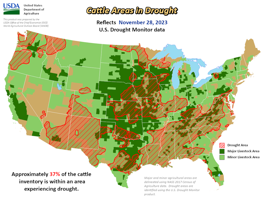
National Current Conditions: November 29, 2023 - December 5, 2023
Inches of rain improved drought conditions in the South & Southeast. However, some of the eastern areas (Virginia, North Carolina, South Carolina) mostly missed out. The Northwest and Hawaii also received abundant precipitation. For the rest of the country, it was mostly status quo.
As of December 5, 2023, 28.85% of the U.S. and Puerto Rico and 34.36% of the lower 48 states are in drought, according to the U.S. Drought Monitor.


This Week's Drought Summary...
This U.S. Drought Monitor (USDM) week saw continued improvements on the map in drought-affected areas of the South, Southeast, and Pacific Northwest. In the South and Southeast, heavy rains over the weekend impacted areas of the Mid-South, and Gulf Coast states with isolated locations in southern Louisiana and the Florida Panhandle receiving up to 7-inch accumulations. In the Pacific Northwest, a series of atmospheric rivers delivered heavy rainfall to western Oregon and Washington as well as significant mountain snow to the higher elevations of the Olympic Peninsula, Cascade Range, and the Blue Mountains of northeastern Oregon. Some of the highest precipitation accumulations (8-15+ inches liquid) were observed in the Olympic Mountains, Cascades of southwestern Washington, and in the coastal ranges of west-central Oregon.
Further inland, higher elevations in central Idaho and northwestern Montana ranges, Northern Great Basin ranges, the Tetons and Wind River ranges in northwestern Wyoming, the Wasatch Range in northern Utah, and the Colorado Rockies all received significant snowfall accumulations that helped to boost snowpack levels closer to normal to above normal levels. Likewise, high-elevation snows were observed in the mountains of the Southwest including along the Mogollon Rim and Chuska Mountains of Arizona as well as in the Nacimiento and Sangre de Cristo ranges of New Mexico.
In California, snowpack conditions continue to lag normal levels with the statewide snow water equivalent (SWE) at 29% of normal (12/5). According to the Natural Resources Conservation Service (NRCS) SNOTEL network (12/5), region-wide (2-digit HUCs) percent of median snow water equivalent (SWE) levels were as follows: Pacific Northwest 73%, Souris-Red-Rainy 70%, Missouri 73%, California 73%, Great Basin 102%, Upper Colorado 86%, Lower Colorado 78%, Rio Grande 65%, and Arkansas-White-Red 64%. In areas of the Midwest, Great Lakes, and northern New England, light-to-moderate snowfall accumulations (ranging from 1 to 12+ inches) were observed during the past week with the highest totals (12+ inches) reported in areas of Vermont, New Hampshire, and Maine. In areas of the Hawaiian Islands, locally heavy showers and flash flooding were observed last week in association with a Kona Low system that helped to ease drought conditions across the island chain.
Looking Ahead...
The NWS 7-Day Forecast calls for moderate-to-heavy precipitation accumulations ranging from 2 to 5+ inches (liquid) across western portions of Washington and Oregon as well as northwestern California, while 1 to 2+ inch accumulations (liquid) are expected in areas of eastern Washington and Oregon, Idaho Panhandle, and northwestern Montana. In the Intermountain West, accumulations around an inch are expected in areas of the northern Great Basin, and the Rockies (central and northern). In the eastern tier of the conterminous U.S., accumulations of 1 to 4 inches are expected with the heaviest totals anticipated in western North Carolina.
The NWS 6-10 Day Outlooks call for a moderate-to-high probability of above-normal temperatures across California, Arizona, Nevada, southern Oregon as well as in the northern Plains, New England, and south Florida. Conversely, temperatures are expected to be below normal across most of the Gulf Coast region, Texas, and eastern New Mexico. In terms of precipitation, below-normal precipitation is expected across most of the conterminous U.S. except for areas of Texas, Florida, and upper New England.


