National Current Conditions: December 13, 2023 - December 19, 2023
Torrential rains improved drought in the eastern Southeast and Mid-Atlantic. Good precipitation also fell on Nebraska, Kansas, ad Oklahoma. In contrast, parts of the South, interior Southeast, and Midwest worsened.
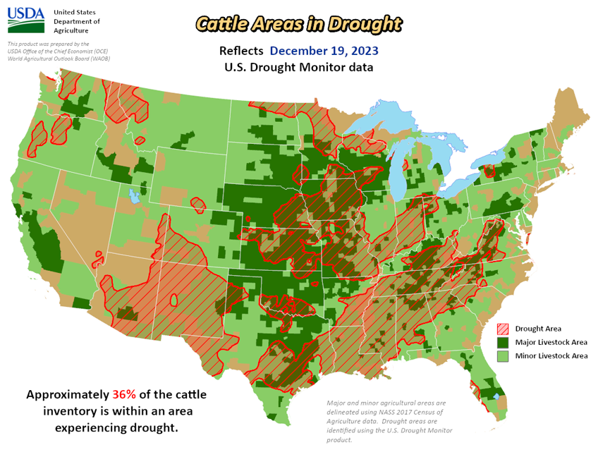
As of December 19, 2023, 27.885% of the U.S. and Puerto Rico and 33.32% of the lower 48 states are in drought, according to the U.S. Drought Monitor.


This Week's Drought Summary...
Moderate or heavy precipitation amounts fell in three main areas this week: central and northern California, parts of the southwestern Great Plains (especially southwest Kansas through the Oklahoma and Texas Panhandles), and along the East Coast. Warmer-than-normal temperatures occurred this week across much of the central and northern contiguous United States. For areas in drought or abnormal dryness that received heavy precipitation amounts, improvements occurred locally due to lessening precipitation deficits and increased streamflow and/or soil moisture. In areas between the southern Great Plains heavy rain and the East Coast heavy rain, deficits in streamflow, soil moisture, and precipitation worsened, leading to widespread degrading conditions. Heavier rains fell on the northeast half of Puerto Rico this week, and scattered moderate drought and abnormal dryness continued on the island. A mix of degradations and improvements occurred in Hawaii this week, with a wet trade wind pattern bringing needed rainfall to windward slopes of Oahu and Molokai. Alaska remained free of drought and abnormal dryness this week.
Looking Ahead...
From Wednesday, December 20 to Christmas evening, the National Weather Service Weather Prediction Center is forecasting three areas of heavier precipitation accumulations. The first, where amounts are likely to be between 0.75 to 3 inches of precipitation, is forecast for far western Oregon and Washington. In the Southwest, 0.75 to 2 inches of precipitation is forecast from Arizona into southern California, with higher amounts possible near and northwest of Los Angeles. From the central Gulf Coast northward to the middle Missouri and Mississippi River Valleys, precipitation amounts are forecast to range from a half inch to 2 inches, with locally higher amounts possible from northeast Texas into western Arkansas, and along the Louisiana, Mississippi, and Alabama coasts.
From December 26-30, the NWS Climate Prediction Center forecast favors below-normal precipitation for most of the region from the Mississippi River and Great Lakes west to the Great Basin. Above-normal precipitation is favored along the West and East Coasts and in deep south Texas. Below-normal temperatures are favored in areas near the Louisiana and Texas coasts. Elsewhere, near- or warmer-than-normal temperatures are forecast for much of the rest of the contiguous United States. Except for southwest Alaska, above-normal precipitation is favored for much of the state. Colder-than-normal temperatures are more likely in the western third of Alaska, while the eastern third is more likely to see warmer-than-normal weather. Drier-than-normal weather is favored across Hawaii, and cooler-than-normal temperatures are favored on the Big Island and the eastern half of Maui.


