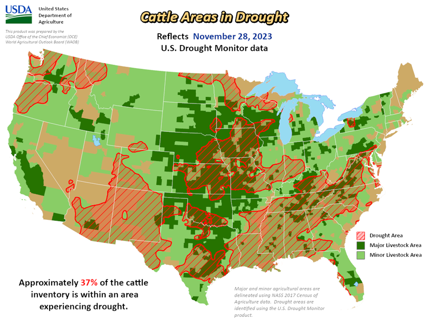
National Current Conditions: November 22, 2023 - November 28, 2023
Almost every region in the U.S. saw improvements to drought or dryness this past week, especially the South/Southeast. However, the Midwest, particularly Illinois and Indiana, worsened. And the South/Southeast still needs a lot more precipitation.
As of November 28, 2023, 30.28% of the U.S. and Puerto Rico and 36.05% of the lower 48 states are in drought, according to the U.S. Drought Monitor.


This Week's Drought Summary...
This U.S. Drought Monitor (USDM) week saw some minor expansion of drought across areas of the West (Colorado, Idaho, Montana, Wyoming) and Midwest (Illinois, Indiana, Missouri), while conditions improved on the map in drought-affected areas of the South (Mississippi, Oklahoma, Tennessee, Texas), Southeast (Alabama, Carolinas, Florida, Virginia), Northeast (Delaware, New Jersey, Pennsylvania), High Plains (Kansas), and the West (Montana, New Mexico). For the week, cooler-than-normal temperatures prevailed across most of the conterminous U.S. with the largest departures observed across areas of the Intermountain West, central and southern Plains, and Texas where temperatures were 6 to 10 degrees below normal. In terms of precipitation, light to heavy snowfall accumulations (2 to 36 inches) were observed across areas of the central and southern Plains, Upper Midwest, and the Northeast with the heaviest accumulations falling in the Northeast. In areas of the South, Southeast, and Mid-Atlantic, light to heavy precipitation accumulations (1 to 4 inches) were observed leading to targeted improvements in drought-affected areas on the map.
Out West, moderate to heavy snowfall accumulations were observed in the mountain ranges of central Utah and western Colorado as well as in northern portions of Arizona and New Mexico. The heaviest accumulations (up to 36 inches) were observed in the San Juan Mountains of southwestern Colorado. Overall, early-season snowpack conditions across the West have been below normal apart from some drainage basins (6-digit HUCs) in the Great Basin, Lower Colorado, and Rio Grande basins. According to the Natural Resources Conservation Service (NRCS) SNOTEL network (11/28), region-wide (2-digit HUCs) percent of median snow water equivalent (SWE) levels were as follows: Pacific Northwest 53%, Missouri 62%, California 39%, Great Basin 62%, Upper Colorado 59%, Lower Colorado 100%, Rio Grande 53%, and Arkansas-White-Red 55%. In the Hawaiian Islands, locally heavy showers and thunderstorms associated with an ongoing Kona Low system are bringing much-needed moisture to drought-affected areas of the island chain this week.
Looking Ahead...
The NWS 7-Day Quantitative Precipitation Forecast (QPF) calls for moderate-to-heavy precipitation accumulations (including heavy snowfall) ranging from 3 to 10+ inches (liquid) across the Olympic Mountains, Cascades of Oregon and Washington, Klamath Mountains, and Coast Ranges of northwestern California. Further inland, lesser accumulations (1 to 3 inches liquid) are expected in areas of the Northern Rockies, northern Great Basin, and ranges of the Intermountain West. In the South and Southeast, moderate to heavy rainfall accumulations (2 to 5 inches) are forecasted while light accumulations (generally <1 inch) are expected in eastern portions of the southern Plains, Lower Midwest, Mid-Atlantic, and the Northeast.
The NWS 6-10 Day Outlooks call for a moderate-to-high probability of above-normal temperatures across the western two-thirds of the conterminous U.S. in an area extending from the Midwest to the West Coast, while near-normal temperatures are expected across most of the eastern tier. Conversely, below-normal temperatures are expected across Florida. In terms of precipitation, below-normal precipitation is expected across much of the southern tier of the conterminous U.S. as well as the central and southern Plains, lower Great Basin, and the central and southern Rockies. Meanwhile, above-normal precipitation is forecasted for the Pacific Northwest, northern California, northern Great Basin, northern Rockies, Mid-Atlantic, and the Northeast.


