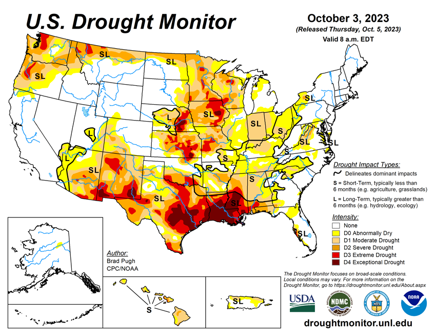
National Current Conditions: September 27, 2023 - October 3, 2023
Drought coverage increased in the United States for the 11th straight week, according to the U.S. Drought Monitor. While the Northwest and Upper Midwest saw improvements this week, conditions worsened in the rest of the Midwest, the Central Plains, Southwest, and South/Southeast. Texas and Oklahoma saw a mix of improvements and degradations.
As of October 3, 2023, 33.62% of the U.S. and Puerto Rico and 40.06% of the lower 48 states are in drought, according to the U.S. Drought Monitor.


This Week's Drought Summary...
The rapid onset and intensification of drought continued across the South with drought expanding northeast from the Lower Mississippi Valley to the Tennessee Valley and Southern Appalachians. A drier-than-normal September led to an expansion of abnormal dryness (D0) and moderate short-term drought (D1) across the Upper Ohio Valley, Eastern Corn Belt, and western parts of Pennsylvania, New York, and West Virginia. Drought of varying intensity persists across the Middle to Upper Mississippi Valley and parts of the Great Plains. However, heavy rainfall at the beginning of October resulted in improvement for the Southern High Plains. A suppressed 2023 Monsoon led to intensifying drought across Arizona and western New Mexico. Early fall precipitation began to ease drought along the coastal Pacific Northwest. Drought continues to worsen along the leeward side of Maui.
Looking Ahead...
During the next five days (October 5-9, 2023), a strong cold front is forecast to progress across the central and eastern U.S. with precipitation amounts of an inch or less across the Ohio Valley with heavier amounts (locally more than 2 inches) for southeastern Oklahoma and eastern Texas. The remnants of Tropical Storm Philippe may become entrained within this eastward-advancing cold front and bring heavy rain and flooding to New England on October 7 and 8. Mostly dry weather is forecast throughout the Southeast. By the second week of October, enhanced onshore flow with associated periods of precipitation are forecast to return to the Pacific Northwest. A major temperature pattern change is likely during this 5-day period as cooler-than-normal temperatures overspread the central and eastern U.S.
The 6-10 day outlook (valid October 10-14, 2023) favors above-normal precipitation along the Gulf and East Coasts. Increased probabilities for above-normal precipitation are also forecast for the Pacific Northwest and Northern Rockies. Below-normal precipitation is most likely across the Central to Southern Great Plains and Southwest. Below-normal temperatures are favored for most of the Northeast, while above-normal temperature probabilities are enhanced from the West Coast to the Mississippi Valley.


