
National Conditions: March 29, 2023 - April 4, 2023
Drought conditions in California and the Great Basin continue to improve. The impending snow runoff will help too but may also lead to floods. Meanwhile, conditions are worsening in parts of the Northwest, Southern Plains, Mid-Atlantic, and Southeast.
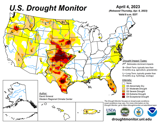
As of April 4, 2023, 23.63% of the U.S. and Puerto Rico and 28.23% of the lower 48 states are in drought, according to the U.S. Drought Monitor.

This Week's Drought Summary...
This U.S. Drought Monitor (USDM) week saw continued widespread improvements on the map across areas of the western U.S. including in California, Nevada, Oregon, Idaho, and Utah. Overall, the areal extent of drought in the West dipped to 31% this week as compared to 73% at the beginning of the Water Year in early October. This week’s improvements reflected the impact of the recent storm events which continued to boost mountain snowpack levels to record, or near-record levels as observed at numerous Natural Resources Conservation Service (NRCS) SNOTEL monitoring stations across the Sierra Nevada, southern Cascades, eastern Great Basin, Wasatch, Uintas, and the southern and central Rockies. In California, the statewide snowpack was 243% of normal (April 5), with the Northern Sierra at 198%, Central Sierra at 242%, and Southern Sierra at 302%. Elsewhere in the region, the state of Utah is observing historic snowpack levels with the statewide snow water equivalent (SWE) at its highest level on record (April 5) at 211% of median, according to NRCS SNOTEL.
In other regions, areas of the South (Texas) and the Southern Plains (Kansas, Oklahoma) saw further degradations on the map in response to a combination of short and long-term dry conditions, very low streamflow and reservoir levels, and reported impacts in the agricultural sector. In the High Plains, blizzard-like conditions and moderate to heavy snowfall accumulations were observed in the Dakotas during the past week as well as in areas of the Upper Midwest including northwestern Minnesota. In the Southeast, dry conditions and reports of deteriorating pasture conditions led to the expansion of severe drought areas in central Florida. Likewise, short-term precipitation deficits and increasing fire danger in areas of the Coastal Plain of North Carolina led to the expansion of areas of drought.
Looking Ahead...
The NWS WPC 7-Day Quantitative Precipitation Forecast (QPF) calls for moderate-to-heavy precipitation accumulations (including heavy snowfall accumulations) ranging from 2 to 7+ inches (liquid) across the Cascades of Oregon and Washington, Klamath Mountains, and Coast Ranges of northwestern California. Meanwhile, light accumulations are expected in the mountain ranges of eastern Oregon and Washington, central and northern Idaho, and across areas of the northern Rockies. Elsewhere in the conterminous U.S., heavy precipitation accumulations (2 to 5+ inches) are expected in the Gulf Coast region of Texas and the South, while the Southeast (excluding Florida) is forecasted to have light-to-moderate precipitation accumulations (2 to 4 inches). In isolated areas of the Upper Midwest and Northeast, light precipitation (<1 inch) is forecasted.
The CPC 6-10-day Outlooks call for a moderate-to-high probability of above-normal temperatures across much of the conterminous U.S. with exception of areas to the west of the Continental Divide where cooler than normal temperatures are expected. Precipitation is forecasted to be above normal across Alaska, the Pacific Northwest, Intermountain West, the Plains states, and in Florida. Below-normal precipitation is forecasted across the South, Eastern Tier, and portions of the Midwest.


