
National Conditions: April 19, 2023 - April 25, 2023
Drought continues to retreat. Next week should bring even more improvements with heavy precipitation just hitting the Southern Plains, storms in Florida, rain coming to the Mid-Atlantic, and western snowmelt.
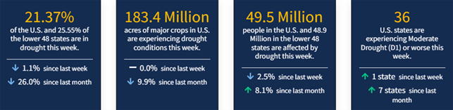
As of April 25, 2023, 21.37% of the U.S. and Puerto Rico and 25.55% of the lower 48 states are in drought, according to the U.S. Drought Monitor.
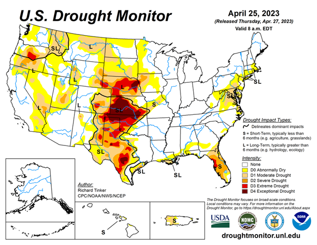
This Week's Drought Summary...
Heavy precipitation fell on areas of dryness in the Northeast, the southern and northern Plains, the northern Rockies, northern Intermountain West, and Pacific Northwest, and more-scattered areas in the mid-Atlantic Region and Florida. Enough rain fell on some extant areas of dryness and drought here to improve drought designations, including parts of the D3 and D4 areas in central to southern Texas.
In contrast, the D3 to D4 areas in the rest of the Plains and the northwestern Florida Peninsula and recorded little or no precipitation, keeping extreme to exceptional drought in place with a few areas of deterioration, especially in central Nebraska and the northwestern Florida Peninsula.
Looking Ahead...
During the next five days (April 26 – May 1, 2023) moderate to heavy precipitation (over 1.5 inches) is expected along the southern tier of the Nation from Texas and the lower Mississippi Valley through central and northern Florida, and along the Eastern Seaboard from Georgia through New England. Parts of the Upper Peninsula in Michigan are also forecast to receive 1.5 or more inches. Very heavy precipitation (3 to 5 inches) are expected in part of northeastern Texas, the central Gulf Coast Region, and southern Georgia. In contrast, little or nothing is anticipated from the High Plains westward, over the central and northern Great Plains, parts of the middle Mississippi Valley, and the southern Great Lakes Region. Moderate to locally heavy precipitation was observed from the Colorado Rockies through the south-central Great Plains and adjacent areas shortly after the Drought Monitor valid period (8 am EDT Tuesday, April 25) ended, with over 1.5 inches observed in scattered areas of central Arkansas, near the Oklahoma/Kansas border, west-central Kansas, higher elevations in the Rockies, and isolated sites across northern Texas. This precipitation will be considered for the Drought Monitor valid May 2, 2023 (next week). Other areas in dryness or drought should see one-tenth to locally one inch. Below-normal temperatures are expected over the southern Great Plains and most of the eastern half of the contiguous states outside the immediate coast in the South Atlantic Region. Meanwhile, warmer than normal weather is anticipated from most of the Plains through interior sections of the West Coast States. Cooler than normal conditions are expected along most of the immediate Pacific Coastline.
The Climate Prediction Center’s 6-10 day outlook (valid May 2 – 6, 2023) Identifies enhanced chances for above-normal precipitation in most of New England, the lower Mississippi Valley, Texas, the southern half of the High Plains, and from the Rockies to the Pacific Coast (except northwestern Washington). Odds for significantly above-normal precipitation exceed 50 percent in the Great Basin, most of California, and some adjacent areas. In contrast, subnormal totals are favored in the Southeast, the lower mid-Atlantic Region, and from the central and southern Appalachians northwestward through most of the Ohio Valley, Great Lakes Region, northern half of the Mississippi Valley, the northern Plains, and the Upper Midwest. Enhanced chances for cooler than normal weather cover California and adjacent areas in the Southwest and Great Basin, and in most locations from the Mississippi Valley to the East Coast. Meanwhile, unusually warm weather is expected from the northern Rockies and Intermountain West through most of the Rockies and the southern half of the High Plains.


