
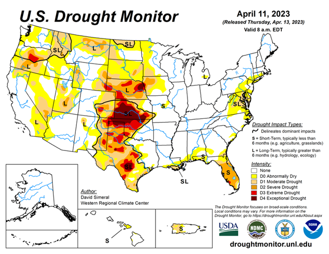
National Conditions: April 5, 2023 - April 11, 2023
The aftermath of the record wet winter continues as drought further shrinks in the West. Meanwhile, the huge area of Exceptional Drought (D4) in the Central/Southern Plains is growing.
As of April 11, 2023, 21.77% of the U.S. and Puerto Rico and 26.02% of the lower 48 states are in drought, according to the U.S. Drought Monitor.

This Week's Drought Summary...
This U.S. Drought Monitor (USDM) week saw continued improvements on the map across areas of the West including California, Nevada, Idaho, Montana, and Utah. In the Plains states, drought-related conditions degraded in the southern Plains in Kansas and Oklahoma. In Kansas, the past 9-month period (July 2022-March 2023) has been the 4th driest on record, according to the NOAA National Centers for Environmental Information (NCEI). In the northern Plains, the conditions on the map improved in response to recent significant winter storm events that helped to boost snowpack conditions in North Dakota where numerous weather stations broke all-time snow depth records for April, according to the North Dakota State Climate Office.
In the South, a mix of improvements and degradation characterized the region’s drought status this week. Significant improvements were observed in South Texas, parts of the Hill Country, and the Gulf Coast regions where locally heavy rainfall accumulations (2 to 8+ inches) were logged. Conversely, areas of western Texas and the Panhandle saw continued degradations in response to short and longer-term precipitation shortfalls.
In the Southeast, above-normal temperatures (4 to 8 deg. F) and generally dry conditions persisted across drought-affected areas of Florida. Further to the north in the Carolinas and areas of southern Virginia, improvements were made related to widespread shower activity, including some locally heavy accumulations (2 to 5+ inches), observed this past week.
In the Mid-Atlantic and Northeast, short-term dry conditions and widespread low streamflow activity led to areas of degradation in Virginia, Maryland, New Jersey, New York, Connecticut, and Rhode Island. Looking at the latest climatological data released by NOAA NCEI, March precipitation across the contiguous U.S. ranked in the wettest third of the historical record (129 years) with well above-normal precipitation (falling in the top 10th percentile) observed regionally across much of the western U.S. including in California (7th wettest), Nevada (6th wettest), and Utah (3rd wettest).
Meanwhile, drier-than-normal conditions for March were observed across much of the Eastern Seaboard including in Virginia, which saw its 8th driest on record. In terms of average temperatures, temperatures were above normal for March across all of the Eastern Seaboard as well as across the southern Gulf Coast states where Florida observed its 8th warmest on record. In the northern Plains and across the West, cooler-than-normal temperatures prevailed with notable anomalies observed in California (5th coldest), Nevada (5th coldest), Oregon (3rd coldest), and Utah (7th coldest).
Looking at snowpack conditions across the West, record-breaking snowpack conditions were observed in the Sierra Nevada, Great Basin, ranges of the Colorado Plateau in Utah and northern Arizona, and in the central and southern Rockies of western Colorado, northern Utah, and southeastern Idaho.
Looking Ahead...
The NWS WPC 7-Day Quantitative Precipitation Forecast (QPF) calls for moderate-to-heavy liquid (liquid = rain + SWE) precipitation accumulations ranging from 2 to 5+ inches across western portions of Oregon and Washington while lighter accumulations (< 1 inch) are forecasted for areas of the northern and central Rockies. The remainder of the West is expected to be generally dry during the next 7-day period. In areas of the Upper Midwest and Northeast, light accumulations (< 1 inch) are expected, while light to moderate accumulations (1 to 4+ inches) are forecasted for areas of the Gulf Coast states with the heaviest accumulations expected in southern portions of Louisiana and Mississippi.
The CPC 6-10-day Outlooks calls for a moderate-to-high probability of above-normal temperatures across the southern and central Plains, South, Southeast, and the Northeast, while below-normal temperatures are expected across areas west of the Rockies and across areas of the northern Plains and Upper Midwest. In terms of precipitation, below-normal precipitation is expected across the far eastern extent of the Midwest and the southwestern portion of the Northeast region, while above-normal precipitation is forecasted for Plains states, Texas, and the northern two-thirds of the western U.S.


