El Niño is expected to begin arriving in the summer, setting up a typical pattern of relief for the drought-stricken southern region of the U.S. and warmer temperatures for the northern portion.
According to the National Oceanic and Atmospheric Administration (NOAA), there is a 62% chance of El Niño conditions for the May-July period. There is an 80% chance El Niño will develop in the fall.
NOAA said computer models are in agreement that El Niño will develop this year. Additionally, sea-surface temperatures in the tropical Pacific Ocean were below the long-term average, indicating it is in a neutral phase, but the warmer subsurface water is beginning to increase.
NOAA continued the chance for a strong El Niño “is about 4 in 10; a clearer picture of the potential strength of El Niño will develop as we emerge from the spring barrier.” The last El Niño in the fall of 2018 through the summer of 2019 was weak.
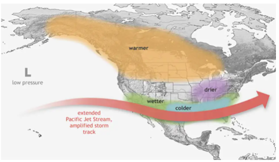
In typical El Niño conditions, the jet stream splits and the southern jet stream is stronger and more active than the northern jet stream. The split results in California being slammed with wet weather, moving through the Southwest, redeveloping in the southern Plains, and then moving through the Southeast. The weaker jet stream in the north results in warmer temperatures resulting in a smaller snowpack through the central portion of the U.S. and the Canadian prairies.


