
National Conditions: February 15, 2023 - February 21, 2023
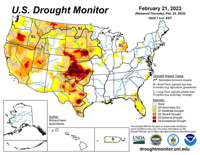
This week, drought conditions remain mostly status quo, and the current extreme weather will impact next week’s U.S. Drought Monitor map. That said, the Upper Midwest, Plains, and a few other areas saw improvements. Meanwhile, southern Texas and Florida continue to worsen.
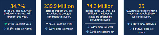
As of February 21, 2023, 34.70% of the U.S. and Puerto Rico and 41.53% of the lower 48 states are in drought, according to the U.S. Drought Monitor.
This Week's Drought Summary...
An upper-level ridge over the northeastern North Pacific Ocean deflected Pacific storm systems away from the West Coast of the contiguous U.S. (CONUS) during this U.S. Drought Monitor (USDM) week (February 15-21). This resulted in a generally drier-than-normal week over much of the West. An upper-level trough developed over the western CONUS downstream from the ridge, and the trough was responsible for a cooler-than-normal week over the West. Strong high pressure over the Gulf of Mexico extended into a ridge across the East Coast. A southerly flow between the trough and eastern ridge spread warm, moist air from the Gulf of Mexico across the eastern CONUS and directed weather systems northeastward from the southern Plains to Great Lakes.
Two weather systems early in the week generated above-normal precipitation across parts of the central to eastern CONUS. As the week ended, weather systems moved across the northern tier states, bringing areas of snow. The week was wetter than normal across parts of the northern Rockies, from the Four Corners states to western Great Lakes, and from the central Gulf Coast states to Ohio Valley and Mid-Atlantic states. It was a drier-than-normal week across much of the West, southern Plains, coastal Southeast, and southern Great Lakes to New England, and parts of the northern to central Plains. Drought or abnormal dryness expanded where it continued dry in parts of the Pacific Northwest, southern Plains, and Florida. Drought or abnormal dryness contracted or reduced in intensity where it was wet over parts of the Four Corners area, southern and central Plains to Upper Mississippi Valley, and the Big Island in Hawaii.
Looking Ahead...
A strong Pacific weather system moved across the West on February 22, with a low pressure and frontal system spreading rain and snow from the Plains to Mississippi Valley and across northern states.
A series of weather systems will follow during February 23-28, spreading an inch or more of precipitation from Oklahoma to the Great Lakes, from the Tennessee to Ohio Valleys, and across much of the Northeast, as well as along the West Coast and into the interior West. Some precipitation totals will exceed 2 inches in the Upper Mississippi Valley and western Great Lakes, and exceed 4 inches along coastal Washington and California and into the Sierra Nevada range. The Gulf of Mexico Coast, western parts of the Great Plains, and parts of the Mid-Atlantic Coast will see little to no precipitation. High pressure over the Gulf of Mexico will keep temperatures warmer than normal from the southern Plains to Ohio Valley and Gulf Coast to Mid-Atlantic Coast, while temperatures will be cooler than normal across the Far West to northern Plains.
For February 28-March 8, the outlook favors colder-than-normal weather across the West and Alaska, with warmer-than-normal weather from the southern Plains to Atlantic Coast and Great Lakes. Above-normal precipitation is likely across Alaska, the western CONUS, and much of the CONUS east of the Rockies except along the Gulf Coast where below-normal precipitation is favored.


