American Farm Bureau Federation
Over 18 months ago, on June 1, 2021, the U.S. Fish and Wildlife Service (USFWS) published a proposed rule in the Federal Register to list the lesser prairie chicken under the Endangered Species Act. With the final rule released, implications of the listing on agriculture in the affected region are becoming more clear. Today’s Market Intel describes some of these possible implications, which could undermine years of voluntary conservation efforts by farmers and ranchers.
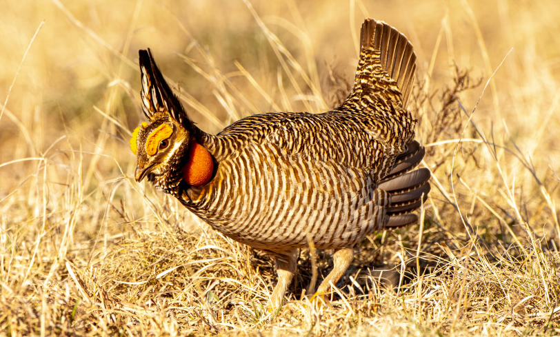
The lesser prairie chicken (LPC) is a medium-sized brown and white striped chicken-like grouse found in western Kansas, western Oklahoma, eastern New Mexico, southeastern Colorado and the Texas Panhandle. The birds inhabit shortgrass prairies and are well known for their lekking behavior in which males gather in small clearings called leks and inflate bright red air sacs in their neck and “dance.” The final rule distinguishes two populations of LPC known as distinct population segments (DPS). The Northern DPS inhabits the Texas Panhandle, Oklahoma, Kansas and Colorado and will be listed as threatened while the Southern DPS, located in West Texas and New Mexico, will be listed as endangered.
The ESA prohibits the “take” of a species listed as endangered which, under the ESA, is defined as “to harass, harm, pursue, hunt, shoot, wound, kill, trap, capture, or collect, or attempt to engage in such conduct.” The act also defines “harm” to include significant habitat modifications or degradation that “kill or injure wildlife by significantly impairing essential behavioral patterns including breeding, spawning, rearing, migrating, feeding or sheltering.” This means many human, crop and livestock interactions with a listed species could be defined as harm if determined by USFWS to be disruptive to that species.
For a species or DPS listed as threatened rather than endangered, special rules and protections are provided under section 4(d) of the ESA that can extend some or all of endangered classification protections but at varying levels. These levels are dependent on goals for a specific species’ conservation at the discretion of the director of the USFWS. Under the 4(d) rule, “take” of the Northern LPC DPS will not be prohibited if that take is incidental to agricultural practices including plowing, mowing and other mechanical manipulation of lands, routine activities that directly support cultivated agriculture and use of chemicals in direct support of agriculture when done in accordance with label recommendations on land that has been cultivated in the last five years. Producers who convert grassland into cultivated land outside this timeframe are not protected under these exceptions.
The 4(d) rule is more specific about grazing. The rule recognizes “the value that livestock grazing provides when managed compatibly and we want to encourage compatible grazing management.” However, the rule sets up a process by which ranchers must follow a site-specific grazing plan developed by a “Service-approved party.” To date, it is unclear what entities will be “Service-approved” and what the process will be for developing a new site-specific grazing plan. The rule goes into effect on Jan. 24, creating significant calendar pressures on this new process. Although criminal penalties are uncommon, violations of ESA take prohibitions can carry civil penalties of up to $25,000 per violation and criminal penalties of up to $50,000 and one-year imprisonment per violation.
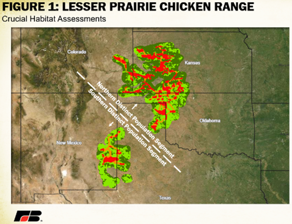
The combined total value of direct agricultural receipts from crops and livestock across the five states inhabited by LPCs is nearly $55 billion or 15% of total U.S. production by value. This includes 37% ($25 billion) of the nation’s cattle and calves, 28% ($2.4 billion) of wheat and 44% ($2.6 billion) of upland cotton production by value. The LPC does not inhabit the entire area of these states, so to calculate a more precise representation of direct agriculture overlap, USDA’s National Agricultural Statistics Service’s county-by-county census of agriculture was overlaid with the Western Association of Fish and Wildlife Agencies’ data on crucial habitat locations. The southern Great Plains Crucial Habitat Assessment Tool (CHAT) separates land area for LPCs into four categories. CHAT 1 areas consist of the most critical focal areas for LPC conservation and where landowners may be most likely to experience encounters. CHAT 2, 3 and 4 consist of less critical but still important land area for LPC conservation such as corridors, lek locations and general occupied range, respectively. All categories within a DPS yield ESA enforcement. Figure 1 displays the breakdown of CHAT distribution by category to show the breadth of land targeted for LPC conservation efforts. In total, over 10,000 square miles of land is designated under a CHAT 1 categorization (roughly the size of Massachusetts) and over 60,000 square miles of land is designated under any CHAT (1-4) category (roughly the size of the state of Georgia) - a significant portion of agricultural land.


