
National Conditions: December 21, 2022 - December 27, 2022
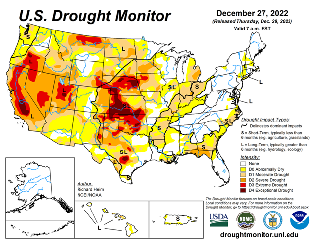
A strong cold front brought below-freezing temperatures across much of the U.S. this past week. The Northeast, Mid-Atlantic, and Great Lakes regions received beneficial precipitation; however, precipitation was minimal for large areas of the Plains and Ohio and Mississippi Valleys, with the cold temperatures freezing soils. Overall, the country saw minimal changes in drought conditions this week, with the largest degradations in the Midwest.
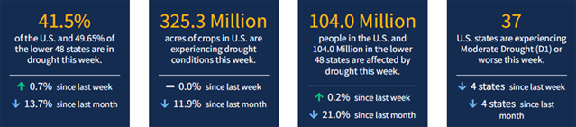
As of December 27, 2022, 41.50% of the U.S. and Puerto Rico and 49.65% of the lower 48 states are in drought, according to the U.S. Drought Monitor.
This Week's Drought Summary...
A powerful low-pressure trough developed in the upper levels of the atmosphere over the eastern contiguous U.S. (CONUS) during this U.S. Drought Monitor (USDM) week (December 21-27). At the surface, the trough was associated with a strong cold front that poured frigid arctic air into the U.S. east of the Rockies. Daytime maximum temperatures in the northern Plains were well below zero degrees Fahrenheit, with minimum temperatures colder than 20 below zero, at the peak of the cold wave. Bismarck, North Dakota, registered minus 10 for a high and minus 20 for a low on December 21 and 22; the high was below zero for 4 consecutive days and below freezing for at least 2 consecutive weeks. Williston, North Dakota, recorded minus 17 for a high and minus 29 for a low on December 20. The freezing arctic air spread to the Gulf of Mexico and East coasts, and even breeched the Rocky Mountain chain to reach the Pacific Northwest. The high temperature at Tupelo, Mississippi, was only 18 degrees with a low of 4 on December 23.
Rain, freezing rain, and snow accompanied the arctic front as it swept east and south. An inch or more of precipitation fell across parts of the Gulf Coast and from the Appalachians to East Coast when the front tapped Gulf and Atlantic moisture. Some parts of the Mid-Atlantic and Northeast states received over 2 inches of precipitation, while an inch or more occurred over the lee sides of the Great Lakes, largely in the form of heavy lake effect snow. Buffalo, New York, officially measured 50.3 inches of snow from December 23-26, but much more snow fell in other favored leeside areas. Locally up to half an inch of precipitation occurred from the northern Plains to Upper Mississippi Valley. But the northwesterly flow was otherwise dry, so large parts of the Great Plains, Mississippi Valley, and Ohio Valley to Gulf Coast received less than half an inch of precipitation to no precipitation. The arctic blast froze soils across much of the Great Plains to Upper Mississippi Valley. Any precipitation that fell was not able to penetrate the frozen ground to increase soil moisture, so much of this region had no change in USDM status.
In reaction to the eastern trough, an upper-level ridge developed over the western CONUS. This kept weekly temperatures near to warmer than normal from California to the Four Corners states, but it also kept much of the West dry. The exception was northern California to the Pacific Northwest and parts of the central and northern Rockies, where Pacific fronts brought areas of rain and snow. Two inches or more of precipitation fell in coastal areas and in the northern Rockies, with up to ten inches in parts of western Washington. Meanwhile Hawaii and Puerto Rico had a mostly drier-than-normal week while drier- and colder-than-normal weather dominated Alaska. The deep freeze and dry weather resulted in status quo conditions for much of the country. Drought or abnormal dryness expanded in parts of the Midwest, Colorado, and Puerto Rico, while contraction occurred in a few areas in the Southeast, East Coast, Wisconsin, Colorado, and Washington.
Looking Ahead...
As the cold air mass over the eastern CONUS exited out of the country during December 27-29, a strong Pacific weather system moved into the West, bringing abundant rain and snow. The western weather system will move across the West and into the central part of the country, while an upper-level ridge shifts eastward to dominate the weather over the East Coast. This combination will result in warmer-than-normal temperatures for much of the CONUS, especially east of the Rockies, and wet conditions from the Lower Mississippi Valley to eastern Great Lakes. The Pacific system will spread several inches of precipitation across much of the West, with 1 to 4 inches already having fallen through December 28. Predicted precipitation amounts for December 29-January 3 range from 1 to 4 inches over the Rockies and higher terrain of the intermountain basin, and from 4 to 10 inches or more along the immediate Pacific Coast, especially in California and the Sierra Nevada. As the weather system moves further east, 1 to 4 inches of precipitation is expected from east Texas to the Mid-Mississippi Valley and in the Southeast. One to 2 inches of precipitation is predicted across the central Plains to Upper Mississippi Valley, across parts of the Great Lakes, and into New England, with half an inch to an inch across the rest of the CONUS east of the Mississippi River.
For January 4-10, the ridge over the eastern half of the CONUS is expected continue, keeping most of the country east of the Rockies warmer than normal, while the West averages near to cooler than normal. Odds favor above-normal precipitation across most of the CONUS, with near to below normal precipitation favored for parts of the northern and southern Plains. Drier-than-normal weather with near-normal temperatures are expected for northern Alaska, and wetter and warmer than normal for southern Alaska.


