The National Weather Service’s (NWS) Climate Prediction Center expects a 91% chance of La Niña through September-November and an 80% chance through January. NWS predicts a 54% chance for La Niña to continue in January-March 2023.
La Niña refers to the large-scale cooling of the ocean’s surface temperature in the central and eastern equatorial Pacific Ocean, coupled with changes in the tropical atmospheric circulation—namely winds, pressure and rainfall. It usually has the opposite impact on weather and climate as El Niño, which is the warm phase of the El Niño-Southern Oscillation (ENSO).
At this time, the consensus is uncertain over how long La Niña will last and when it will transition to ENSO-neutral. Statistical models show a 56% chance of a transition to ENSO-neutral during February-April 2023.
The World Meteorological Organization concurred with the NWS and said there is a 70% chance a La Niña event will last until at least the end of the year, becoming this century’s first “triple-dip” La Niña, spanning three consecutive Northern Hemisphere winters starting in 2020.
Of the 24 La Niña winters dating back to 1950, only one (2016-17) changed to neutral in December-February, four transitioned to neutral in January-March, one (2000-01) transitioned by February-April, two transitioned by March-May and 16 transitioned in April-June or later.
According to NWS, if La Niña prevails, there is a 46% chance it will be moderate or strong in early winter.
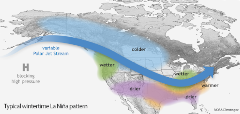
La Niña conditions will mean less rain and drier conditions this fall for most of the U.S. NWS is predicting warmer-than-average temperatures through the fall—except along the Canadian border—and below-average rainfall in the Plains.
Previous La Niña years resulted in early rainfall in California and the Southwest, followed by drier conditions and the worsening of drought. Hotter, drier summers in the southern Plains and Texas followed a La Niña winter. The Northwest experienced wetter conditions.


