
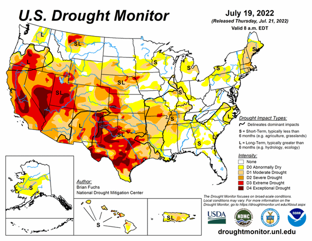
National Current Conditions: July 13, 2022 - July 19, 2022
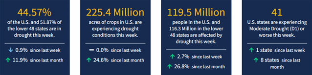
Extreme heat and dryness in the Southern Plains and Missouri/Arkansas led to another week of major degradations. However, parts of the Midwest (which have been experiencing flash drought) and the Southeast saw good rain and improvements. As of July 19, 2022, 44.57% of the U.S. and 51.87% of the lower 48 states are in drought.
This Week's Drought Summary
Most of the eastern third of the U.S. recorded precipitation during the last week, with only a few pockets that missed out. Portions of the Midwest and into the Southeast had some amounts over 3 inches for the week and even widespread 5+ inch amounts in the coastal areas of Florida, and some rain at the end of the period allowed for much of New England to stay status quo for the week and even see a few improvements. The areas with the most rain also had the coolest temperatures, with much of the Midwest and Southeast cooler than normal for the week with departures of 2-4 degrees below normal. Warmer-than-normal temperatures dominated the western half of the country with areas from Montana to Texas recording temperatures that were 6-8 degrees above normal. The coastal areas of the Pacific Northwest were cooler than normal while the Great Basin was warmer than normal with departures of 6-8 degrees above normal. With the dryness and heat, the flash drought that has been developing in the central to southern Plains developed even more this week with the wet conditions of May and June quickly being forgotten.
Looking Ahead
Over the next 5-7 days, it is anticipated that wet conditions will continue over the Southeast and along the Gulf Coast. Areas of the Midwest will also continue with the recent wet pattern, with the greatest rains anticipated over southern Wisconsin. Dry conditions will dominate the West and South and monsoonal moisture will continue to bring rains to the Four Corners region and into the central Plains. Temperatures during this time will be above normal for most of the country; the greatest departures of 6-9 degrees above normal will be over the West and into the Plains. Cooler-than-normal conditions will be experienced over the northern Plains, where temperatures in North Dakota are anticipated to be 6-9 degrees below normal.
The 6-10 day outlooks show that the West, South, Midwest and East Coast have the best chances to record above-normal temperatures, with the best chances over the South and Pacific Northwest. The best probability for below-normal temperatures will be over the northern Plains, southern Arizona and Alaska. The best chances of above-normal precipitation appear to be over the central to southern Plains, Southwest and Midwest, with the best chances over Kansas, Oklahoma, and Kentucky. Below-normal precipitation chances are best over the Pacific Northwest and into portions of the Southeast.


