National Current Conditions: May 18, 2022 - May 24, 2022
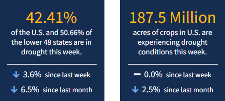
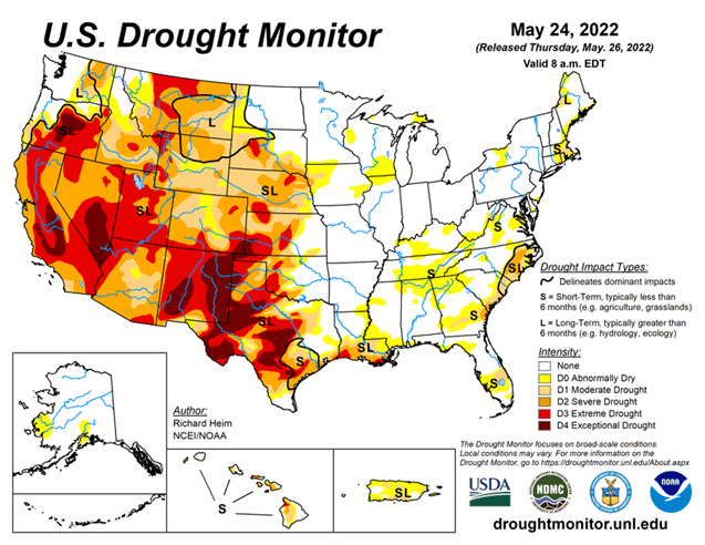
There was a bit of a divergence with the two most drought-stricken regions this week. The Southwest continued to worsen, while the Southern Plains got drenched. Even so, the western Southern Plains remain exceptionally dry. As of May 24, 2022, 42.41% of the U.S. and 50.66% of the lower 48 states are in drought.
This Week's Drought Summary
A strong upper-level trough moved across the contiguous U.S. (CONUS) during this U.S. Drought Monitor (USDM) week (May 18-24). Surface low pressure systems and cold fronts were associated with this complex trough. They tapped Gulf of Mexico moisture to spread above-normal precipitation across parts of the Plains, Midwest, Southeast, and Mid-Atlantic Coast, and locally heavy snow across parts of Colorado. One of the fronts moved very slowly across the southern Plains near the end of the week, dumping locally heavy rain on parts of Oklahoma and Texas. Precipitation also fell across parts of the Pacific Northwest, North Dakota, and western Great Lakes. Most of the West was drier than normal, with much of the area from Oregon to California and southern Idaho to New Mexico receiving little to no precipitation. Weekly temperatures averaged below normal behind the fronts from the Pacific Northwest to Great Lakes and from the northern Rockies to Mid-Mississippi Valley. Temperatures averaged warmer than normal across the eastern third of the CONUS and from California to Texas. The continued lack of precipitation in the dry areas further dried soils, lowered stream levels, and stressed crops and other vegetation, while the warmer-than-normal temperatures increased evapotranspiration that added to the stress caused by lack of precipitation. But widespread heavy rain fell across several drought areas, contracting drought and abnormal dryness, especially in the central to southern Plains, Lower Mississippi Valley, Southeast, and Mid-Atlantic states. Drought and abnormal dryness also shrank in the Pacific Northwest where drought indicators showed improving conditions. Drought or abnormal dryness expanded or intensified where it continued dry, especially in southern parts of the West, in the Ohio and Tennessee Valleys, and parts of southern New England.
Looking Ahead
A strong upper-level low pressure system slowly moved across the Plains during May 24 and 25, spreading heavy rain over the southern and central Plains to Lower and Mid-Mississippi Valley. This weather system, with its surface low and fronts, will move slowly eastward during the next several days. Another upper-level low pressure system will move from the Pacific Ocean into the western CONUS by Sunday. In addition to the 1+ inches of rain that has already fallen across the Plains to Mississippi Valley May 24-25, another 1 to 2 inches is expected from the Mississippi Valley to Appalachians and northward to the Great Lakes through May 31. An inch or more of precipitation is forecast for the Pacific Northwest to northern Plains and parts of the Interior Basin in association with the western weather system. Little to no precipitation is expected through May 31 for southern states in the West, and no additional precipitation is forecast for Texas and western portions of the southern High Plains. Warmer-than-normal temperatures are forecast for May 26-31 for the central to southern Plains ahead of the western weather system, while clouds and rain will keep high temperatures near to cooler than normal in the West and East.
For May 31-June 4, odds favor above-normal precipitation in the Pacific Northwest, Great Plains, Southeast, and most of Alaska, but below-normal precipitation for the Midwest to Northeast and California to southern Nevada. Warmer-than-normal temperatures are likely for May 31-June 4 across most of Alaska and the eastern half of the CONUS, while odds favor cooler-than-normal temperatures from the Great Basin to northern Plains.


